Cole Shoal Rear Range Lighthouse
Elizabethtown, Ontario - 1916 (1916**)

History of the Cole Shoal Rear Range Lighthouse
Posted/Updated by Bryan Penberthy on 2015-10-06.
As the St. Lawrence River is the only waterway to link the Atlantic Ocean and the Great Lakes, both the governments of Canada and the United States established numerous lights to help improve its navigation. The Cole Shoal Rear Range Lighthouse was one such light erected on the Canadian side of the river.
As traffic along the St. Lawrence River increased in the mid-1800s, the United States commissioned Lieutenant Charles T. Platt, U.S. Navy, to survey the river in November 1838. In his report, he recommended the construction of three lighthouses - Sunken Rock, Rock Island, and Crossover Island, which would be constructed in 1847 / 1848.
About that same time, the Canadian side of the St. Lawrence River was seeing an uptick in steamer traffic and more vessels traveling at night. To protect the busy waterway, the Canadian government, focusing on the area between Kingston and Brockville, recommended the placement of nine identical wooden lighthouses.
One such light, the Cole Shoal Lighthouse, was erected on a set of piers off shore from Cole's Ferry, a small town about five miles west of Brockville, Ontario. The wooden lighthouse was 31 feet tall, with 12-foot sides, tapering as it rises. At its top was a four-foot box topped with an octagonal lantern.
You can read more about the history of the Cole Shoal Lighthouse here.
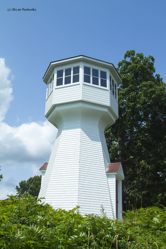
Although the Cole Shoal lighthouse was supposed to be part of a pair of range lights, that originally did not happen. In fact, it didn't happen until 1916, when the Cole Shoal Rear Range Lighthouse was constructed.
Nearly 1,200 yards to the northwest of the Cole Shoal Lighthouse, a small parcel of land was purchased from Sherwood Fulford. A local carpenter named Albert I. Munro constructed the rear range light in 1916. When completed, the new light was published in the Index to Notices to Mariners - NOS. 1 To 53 Inclusive published in 1916. Below is a summary of the notice:
(771) ST. LAWRENCE RIVER - Above Montreal - Cole Shoal Light - Rear range light established. 0n the opening of navigation in 1916, and without further notice, a fixed white catoptric light of 2,700 candlepower, which will constitute the rear light of the Cole Shoal Range, will be established on the northern shore of the St. Lawrence River, 1,200 yards 21° 30' from the existing front light on Cole Shoal.
The light will be exhibited, 107 feet above the summer level of the river, from an enclosed octagonal tower with sloping sides, painted white, surmounted by an octagonal iron lantern painted red, and will be visible 8 miles in the line of range.
The height of the tower, from its base to the top of the ventilator on the lantern, is 33 feet.
The lights in one, bearing 21° 30', lead from Superior Shoal Gas-buoy to Cole Shoal.
John E. Locke was the only keeper to serve at the lighthouse and would serve until the rear light was abandoned in 1923. Both the rear range and the Cole Shoal Lighthouse were discontinued in 1927 when the new DeWattville range lights were implemented.
Rather than tearing the rear range lighthouse down, it was left standing in the event that the new range lights were deemed ineffective. That never happened and over the years, many people offered to buy or lease the abandoned Cole Shoal Rear Range Lighthouse, but the government rejected the offers. At some point, the lantern was removed from the tower.
It would take a decade, but the Canadian government put the Cole Shoal Rear Range Lighthouse and its land up for sale in 1937. The property was purchased by Albert I. Munro, the tower's builder for $100. He subsequently renovated it, enclosing the top to create a room. At some point, decorative blades were added to make it look like a windmill, which were later removed.
The tower's ownership still remains in the Munro family today.
Note: The lighthouse is private property, please respect this and do not trespass.
Reference:
- Annual Report of the Department of Marine and Fisheries, Government of Canada, Various years.
- "Cole Shoal Lighthouse," Mary Alice Snetsinger, http://www.thousandislandslife.com/, April 13, 2014.
- Index to Notices To Mariners NOS. 1 To 53 Inclusive, U.S. Navy, 1916.
Directions: The lighthouse is located on Fulford Point Road, just off Highway 2 west of Brockville.
Access: The lighthouse is private property, please respect this and do not trespass. Grounds and tower are closed.
View more Cole Shoal Rear Range Lighthouse picturesTower Height: 26.00'
Focal Plane: Unknown
Active Aid to Navigation: Deactivated (1927)
*Latitude: 44.54200 N
*Longitude: -75.75200 W
See this lighthouse on Google Maps.