West Chop Lighthouse
Vineyard Haven, Massachusetts - 1891 (1817**)


History of the West Chop Lighthouse
Posted/Updated by Bryan Penberthy on 2013-12-13.
During the eighteenth and nineteenth centuries, the whaling industry was prominent amongst the islands in Massachusetts. The settlements of Edgartown on Martha's Vineyard and Nantucket were some of the busiest whaling ports in the state.
A lighthouse ten miles to the east in Edgartown was established in 1801 at Cape Poge and a lighthouse twelve miles to the west was established at Tarpaulin Cove in 1817 leaving residents of the much busier port at Holmes Hole feeling slighted.
Prior to the opening of the Cape Cod Canal in 1914, all maritime traffic between Portland, Maine and ports to the south such as New York had to pass through Vineyard Sound between the northern side of Martha's Vineyard and the Massachusetts's main coastline.
Locals felt there was a need for a lighthouse at Holmes Hole on the northern point of the island to safely guide vessels into the harbor, as well as assist the vessels passing through Vineyard Sound.
There are two prominent points of land that mark the entrance to Holmes Hole, now known as Vineyard Haven Harbor on the island of Martha's Vineyard, the East Chop and West Chop. The word Chop (or Chap) is an old English term adopted in the seventeenth century to describe the entrance to a river, bay, or harbor.
As early as February 1816, a resident of the island, Thomas Dunham wrote to Representative John Reed of Congress requesting a lighthouse be erected on the West Chop of Holmes Hole. Mr. Dunham felt that a lighthouse on the West Chop of Holmes Hole would be the ideal place to guide vessels clear of shoals.
It took nearly a year, but Congress was finally convinced that a lighthouse would be beneficial at West Chop. On March 3, 1817 an appropriation of $5,000 was made "for building a light-house on the West Chop of Holmes Hole...and to furnish the same with all necessary supplies."
The contract specified that the lighthouse be built of stone, shape being round, and standing 25 feet tall. The diameter at the base was to be 18 feet with walls three feet thick and painted white. The tower was to be topped off with a black octagonal iron lantern.
The contract went on to specify that a one-story keeper's dwelling be constructed of stone in the dimensions of 34 feet by 20 feet consisting of two rooms over a cellar six feet deep.
Most early light stations called for the kitchen to be an addition to the house called a "porch." Attached to the dwelling was to be a porch measuring 12 by 14 feet which included many of the kitchen items such as an oven, and sink with spout.
Lastly, the contract requested an outhouse measuring four feet by five feet, shingled and painted, and a well of stone sufficiently deep to procure good water. The contract requested that all work be completed by October 1, 1817.
Of the three firms that submitted bids for the project, the firm of Beall & Thaxter of Hingham, Massachusetts submitted the winning bid of $4,850. Four acres of land was procured from Abijah and Mary Luce of Boston for $225. When the contractor, Duncan McBean completed the requested work, it was inspected by Thomas Cooke, the local customs collector from Holmes Hole. Once the inspection was complete, the contract was paid.
The light went into service on October 5, 1817. Although William Daggett was recommended as keeper of the new lighthouse, his appointment was rescinded before appointment. James West was recommended as the first keeper of the West Chop Lighthouse.
Like most lighthouses in the northeast, the West Chop Lighthouse was inspected in 1838 by Lieutenant Edward W. Carpender. Although most of his inspections produced critical reports, his report of this lighthouse was largely favorable:
Holmes's Hole light - I return to Martha's Vineyard, to the light at the west chop of Holmes's Hole harbor, 9 miles to the northward and westward of Cape Poge, and 4 miles to the southward and eastward of Nobsque light. This light is in a stone tower, 25 feet high, and 60 above the level of the sea; it consists of 10 lamps, with 13.5 and 15-inch reflectors, arranged in two equal series or tiers. Though an exceedingly useful light, six lamps, compactly arranged in a single series, are abundance for it. I found this light in admirable order; reflectors bright, glass perfectly clean, lamps carefully trimmed, and everything justifying the high reputation it enjoys along the coast.
The sea is encroaching upon this tower and dwelling, and, in the event of its becoming necessary to remove them, I recommend that the light be placed about three hundred yards farther to the southward, on a site much approved by the pilots, directly opposite a shoal on which vessels are apt to strike, supposing that after they have passed the lights, to enter the harbor, they are out of danger. No less than 127 vessels have been ashore here during the twenty years this keeper has attended light. It might be necessary to raise the tower a few feet, so the light could be seen along the passage between the shoal called the Middle ground, and the western shore of the island. Premises in good order. There is one buoy in this harbor.
Realizing that the land around the lighthouse was eroding, Collector J.T. Pease purchased a parcel land adjacent to the current location from Abner West and David P. West in 1841 for $231.62.
In a letter dated October 3, 1842, Keeper James West brought forth many deficiencies with the station. Along with the many issues with the keeper's dwelling and tower, such as rotten woodwork, leaks in the walls, and the house being damp and cold, he also noted the erosion encroaching on the station:
The bluff on which the tower stands has washed away to within 37 feet of the base, and I consider the buildings unsafe in their present position. I have known 30 feet of the bluff to wash away in one storm.
A report several years later of I.W.P. Lewis was more scathing of the station. The 1843 report echoed many of the same sentiments of Keeper James West.
Tower was built of rubble masonry laid up in bad lime mortar, base resting on gravel one foot below surface, walls cracked and leaking, roof soapstone, loose and leaky, woodwork rotten, whole structure out of repair. Windows, door frames and floor timbers are studded up to preserve level of floors. House damp and cold. Present keeper deserves great praise for great neatness of the establishment.I.W.P. Lewis's report also commented on the erosion. He noted that the bluff eroded to within 37 feet of the buildings, and made a recommendation to move the structures back to the previous bluff. Bids were advertised in a local newspaper by J.T. Pease, Collector of customs to take down, move, and rebuild the tower and dwelling.
Although Winslow Lewis, a regular lighthouse builder and friend of Stephan Pleasonton, fifth auditor of the Treasury, submitted a bid, it was not accepted. Instead, he was awarded a contract to construct and supply a new lantern for the tower. The contract to take down, move, and rebuild the station went to Marshal Lincoln of Hingham, Massachusetts with the winning bid of $2,339. He signed the contract on August 20, 1846.
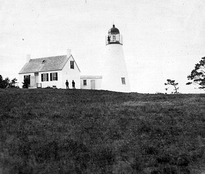 1847 West Chop Lighthouse (Courtesy Coast Guard)
The station was rebuilt later that year. A round stone tower and a stone Cape Cod style keeper's dwelling were erected about 1,000 feet to the southeast of the original location. The old keeper's house was moved to the nearby town of Tisbury where it became the home of Keeper West's son, Gustavus.
The next year, Keeper James West completed an affidavit stating that the woodwork in both structures was rotten, the walls were leaking, and that the dwelling was damp and cold. To rectify the situation, the tower was enclosed in a wooden shell and shingled to keep out leaks. The wooden shingles gave the tower an octagonal appearance.
The lighting apparatus was swapped out with updated system of lamps and reflectors in 1848. Several years later, the lighthouse was upgraded to a more efficient fourth-order Fresnel lens. Starting in 1857, to act as a range system to guide ships into the harbor, an additional light was placed on the roof of the keeper's house.
The Annual Report of the Lighthouse Board dated 1882 stated that a frame engine house was erected and a steam whistle was established. Also constructed at that time was a one-and-a-half-story frame dwelling. The additional dwelling would serve as a residence for a new assistant keeper, George Dolby that would now be necessary to handle the fog signal duties.
Minor changes were made to the station over the next few years. In 1883, the chimney was raised five feet to give a better draft, a new pump and pipes were installed, and whistle valves were repaired. In 1885, the station was enclosed with a barbed-wire fence.
The stone dwelling that was constructed in 1846 was torn down in 1888 to make way for a second wood-frame dwelling. The following year, a red sector was installed to cover Squash Meadow and Norton's Shoals. To increase the fresh water available for the steam signal, a new pipe well was driven in the fog signal house.
In 1889, the government sold the roughly three-acre tract of land that the original 1817 lighthouse was on. The tract of land was sold at public auction to land developers for $650, who subdivided the property into lots. After creating a municipal water supply, the area was advertised as a "wonderful location for summer cottages with fresh air and grand views."
The advertising worked and many cottages were constructed. Some were so large that they blocked the view of the lighthouse. To provide short term relief of the situation, an additional light was attached to a seventeen-foot iron pole which was affixed to the lantern deck in January of 1891.
By late in the year, the old tower was in poor condition and needed replacing. The following entry was made in the Annual Report of the Lighthouse Board dated 1892. The brick tower was left its natural red color.
129. West Chop, entrance to Vineyard Haven Harbor, Massachusetts - The old tower of rubble masonry, built in 1846, was demolished and a new tower of brick, 45 feet high, was built on the old foundation.
West Chop, Vineyard Sound, Massachusetts - Transferred to a new tower, 17 feet higher than the old tower, erected on the old site, December 31 1891.
The illuminant of the light starting in the 1860s was lard oil which was stored in the tower. However, when it was changed over to the more volatile kerosene, a separate oil house was built in 1895 to store the substance at a safe distance from the tower.
In 1896, the dwellings at the West Chop Lighthouse were connected to the Vineyard Haven Water Company; however, it would take another three years before the fog signal was switched over. Later that year, the tower was painted white to help it stand out against the summer "cottages."
Octave Ponsart became keeper in 1946. Along with his duties of keeping the light at West Chop, he also had to periodically check on the automated lighthouses at East Chop, Edgartown Harbor, and Cape Poge, all of which were nearby.
Of the five lighthouses on the island of Martha's Vineyard, the West Chop Lighthouse was the last to lose its keeper, being automated in 1976. Vineyard Environmental Research Institute had its offices in the houses for several years before vacating. Both dwellings are now occupied, one by the office-in-charge of the Menemsha Coast Guard station, and the other for an enlisted family at the same station.
Reference:
- "West Chop Lighthouse," Wayne C. Wheeler, The Keeper's Log, February 2013.
- America's Atlantic Coast Lighthouses (6th edition), Jeremy D'Entremont, 2005.
- Annual Report of the Light House Board, U.S. Lighthouse Service, Various years.
- The Lighthouses of Massachusetts, Jeremy D'Entremont, 2007.
- The Lighthouse Handbook: New England: The Original Field Guide, Jeremy D'Entremont, 2008.
Directions: From Vineyard Haven, follow Main Street (West Chop Road) north out of town for about two miles. The lighthouse will be on the right just past Minnesota Street.
Access: The lighthouse is owned by the Coast Guard. Grounds and tower closed.
View more West Chop Lighthouse picturesTower Height: 45.00'
Focal Plane: 84'
Active Aid to Navigation: Yes
*Latitude: 41.48081 N
*Longitude: -70.59987 W
See this lighthouse on Google Maps.