Sea Girt Lighthouse
Sea Girt, New Jersey - 1896 (1896**)


History of the Sea Girt Lighthouse
Posted/Updated by Bryan Penberthy on 2011-05-01.
With shipping traffic increasing into New York Harbor and along the eastern seaboard in the 1880s, the Lighthouse Board sought to improve lighting. With nearly forty miles of unlit coastline between the Navesink and Barnegat Lighthouses, the Lighthouse Board knew that during inclement weather mariners could lose sight of the lights. Realizing that this was unacceptable, a proposal was put forth for the construction of a lighthouse around the midway point.
Congress agreed with the Board's proposal and authorized $20,000 on October 19, 1888. The Lighthouse Board had selected an area near Squan (Manasquan) Inlet in 1889, which was a well used harbor of refuge along the coast. However, before the deed was signed over, it was determined that the location was sub-optimal. It would take several years, but a better location was found several miles to the north in the Wreck Pond area. The land was purchased on July 29, 1895. This would put the tower 19 miles south of Navesink Lighthouse and 26 miles north of the Barnegat Lighthouse.
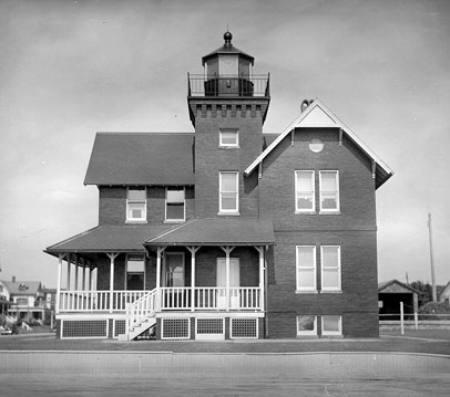 Sea Girt Lighthouse (Courtesy Coast Guard)
Construction was started on a two-story brick "L-shaped" Victorian style dwelling with the tower rising out of the "elbow", making this the last live-in lighthouse constructed on the Atlantic coast. Also constructed on site at that time were an oil house and a well. Inside the lantern room, a fourth order Fresnel lens powered by a kerosene lamp would cast a red flash visible for 15 miles into the ocean. Major Abraham Wolf, a retired Army officer and the station's first keeper, would light the lamp for the first time on December 10, 1896.
Wolf, while serving in the Union Army, would infiltrate the Confederate Army. He had a unique ability to emulate a southern accent so perfectly, that his commanding officer would dress him up in a Confederate uniform and put him in with captured troops at a Delaware prison camp. There, he would speak with the Confederate soldiers to gather information on troop strength and plans.
Even though the lighthouse was constructed at Sea Girt and not at the Squan Inlet location like originally planned, it was still known as the Squan Inlet Lighthouse for several years. Unofficially, people called it the Sea Girt Lighthouse due to its proximity to the Inlet. However, it would be March of 1897 before the name change was made official.
Like most of the lighthouses along the New Jersey coastline, the Sea Girt Lighthouse was also threatened by erosion. In 1900, the Army Corp of Engineers would build a 240 foot wood and sand fence near the lighthouse to try to slow the erosion which came from ocean and the Wreck Pond area to the north. In 1915, the wood and sand fence was replaced with steel pilings to try to offset the continued erosion. The problem wouldn't completely go away until May of 1938 when the Sea Girt Inlet was dammed up. This action effectively dried up the inlet which ended the erosion.
Over the years, the lighting apparatus would be upgraded. The original kerosene lamp was swapped out in 1912 in favor of a 35mm incandescent oil vapor lamp. Also at this time, the red panels were removed changing the light from red to white. In 1924 the incandescent oil vapor lamp was replaced with a 300 watt PS35 lamp which rated to 100,000 candlepower.
The Lighthouse Board began testing radio communication as early as 1917, but it would be May 1, 1921 before the system would be deployed. The Lighthouse Board had chosen the Sea Girt Lighthouse to be one of the three locations in the New York Harbor area to set up a radio beacon network. The other two locations selected would be the Fire Island and the Ambrose Lightships. Each location had a unique sequence of dashes or dots to identify it and would broadcast its sequence for two minutes. After a one minute delay, the next station would broadcast its sequence for two minutes. After another one minute delay, the final station would broadcast its sequence. The broadcasts would start over every ten minutes. By using this system, the sea captain could plot his position on the navigation chart in relation to the locations and bearings of the transmitters. The transmitter at Sea Girt would only last until 1928 when it was removed and placed on the Barnegat Lightship.
In 1941, as the United States was entering World War II, the beacons at all lighthouses were ordered dark. The Fresnel lens was removed to increase the room in the watch room. Soldiers and Coast Guard personnel were ordered to stand watch for enemy vessels and perform frequent beach patrols. In 1945, when the war was over, Sea Girt received an aerobeacon and was automated. The structure would continue to house the light for nine years until it was moved to a freestanding metal tower. In 1956, the federal government offered the lighthouse to the state, which turned them down. The Borough of Sea Girt purchased the lighthouse for $11,000. Over the next 20 years, it would see use as a community center, a library, and even a recreation center.
The heavy use over the years took its toll. By 1980, the lighthouse was in need of many costly repairs. The Borough considered selling the property, by local citizens resisted and instead formed the Sea Girt Lighthouse Citizens Committee to save the lighthouse. The group leased the lighthouse from the Borough of Sea Girt in 1981 for the sum of $1.00 a year assuming responsibility for all maintenance. The group has since gone on to complete a full restoration of the lighthouse, and has renewed the lease through 2051.
Reference:
- Sea Girt Lighthouse website.
- New Jersey Lighthouse Society website.
- Mid-Atlantic Lighthouses, 2nd: Hudson River to Chesapeake Bay, Bruce Roberts and Ray Jones, 2005.
- Down The Jersey Shore, Russell Roberts and Rich Youmans, 2003.
Directions: From Route 71 in the Town of Sea Girt, take Beacon Ave. east to Ocean Ave. The lighthouse is on the north corner of Beacon and Ocean Aves.
More information is available at: http://www.seagirtlighthouse.com.
Access: The lighthouse is owned by the Borough of Sea Girt and is operated by the Sea Girt Citizens Committee. The grounds are open. The tower is open in season.
View more Sea Girt Lighthouse picturesTower Height: 44.00'
Focal Plane: 60'
Active Aid to Navigation: Deactivated (1977)
*Latitude: 40.13600 N
*Longitude: -74.02700 W
See this lighthouse on Google Maps.