Oak Island Lighthouse
Caswell Beach, North Carolina - 1958 (1849**)


History of the Oak Island Lighthouse
Posted/Updated by Bryan Penberthy on 2013-02-24.
As commercial activity flourished in North Carolina in the mid-1700s to the 1800s, Wilmington became one of the largest ports in the state. A hurricane struck the area on September 23, 1761 carving out a new inlet near the mouth of the Cape Fear River. This new inlet would shorten the travel time to the Port of Wilmington, and would become the preferred route of mariners.
The Oak Island Range Lighthouses, authorized on August 14, 1848, were two of eight lighthouses constructed during that time to increase the navigability of a twenty-five mile section of the Cape Fear River. Other range lighthouses authorized by the same act were for Upper Jetty and Price's Creek. Single lighthouses (non-range lights) were constructed at Orton Point and Campbell Island.
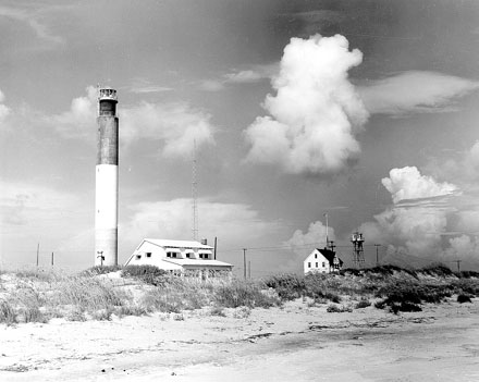 Oak Island Lighthouse (Courtesy U.S. Coast Guard)
Unlike the Price's Creek Range Lighthouses where the rear range also served as the living quarters for the keeper, the Oak Island Range Lights were free-standing brick towers. A separate one-and-one-half-story keeper's house was constructed nearby. The station was completed on September 7, 1849.
The front range lighthouse stood twenty feet tall with a focal plane of twenty-seven feet and displayed a fixed white light. The rear range lighthouse stood thirty-feet tall displaying a fixed white light that had a range of nine miles.
John G. Brickman was appointed keeper of the range lights on September 3, 1849. Report of the Officers Constituting the Lighthouse Board dated 1851 described the lights as the following:
Towers were built in 1849, of brick; look very well; lime-mortar; do not leak; one 20 feet and the other 30 feet in height. Lanterns of heavy iron. Astragals vertical and very broad. Glass of lantern 28 X 12 inches. Ten reflectors, 14-inch spherical, in each tower.
They were used until their destruction during the Civil War by retreating Confederate soldiers.
Plans were drawn up in 1865 for a new set of range lights. The rear range light was much different from the previous light. The new plans called for a rear range light containing four levels made up of a living / kitchen level on the bottom, sleeping quarters, oil and store room in the middle, and watch level at the top. The plans showed the front range light being twenty-seven feet tall and only its upper story would be enclosed to serve as a watch room. Although these plans were drawn up, they were never used.
On June 23, 1874, an appropriation of $4,000 was made by Congress for two new beacons to mark the Oak Island Channel. The Annual Report of the Lighthouse Board dated 1875 had the following entry:
332, 333. Oak Island Range beacons, entrance to Cape Fear River, Carolina - An appropriation of $4,000 was made by the act June 23, 1874, for building two new frame beacons to take the place the present ones, and to secure a better range. A survey of the locality shows that the range can be moved to the eastward and give better water through the western or Oak Island channel; also that the light can be located in a position that will, with another light placed Battery Island, serve the purpose of a range through the channel being dredged on the westerly side of Cape Fear River, between Horseshoe Shoals and Marsh Island. The Bald Head channel has now 11.5 feet of water at ordinarily low tide, with a prospect of that depth being maintained, and even increased by further dredging operations, while Oak Island Channel is reported as shoaling. Steamers now use latter but little, but it is considered important to maintain the Oak Island range for the present, as sailing-vessels use the channel to shelter between the bar and the rip off Fort Caswell. The board has ordered the work to be suspended until it is determined whether changes in the channels now taking place are of a permanent nature.
After several years of waiting to see how the channels would fare, by 1878, it appears that the Lighthouse Board was under some pressure to make a decision. The Annual Report of the Lighthouse Board had an entry stating that the "matter is now under consideration of the board."
Another set of range lighthouses were constructed in 1879. Although some books and websites claim that the front range light was a wooden tower with gingerbread-house elements built upon a sixteen-foot high by fourteen-foot wide brick foundation and that the rear range light was a simple one mounted on skids so it could be easily moved when the channel periodically shifted, this is incorrect.
It is actually the reverse which is correct. The rear range light had gingerbread styling with an enclosed watch room and the front range was a simple light built on skids to be moved along a tramway. Also constructed at that time was a two-story keeper's dwelling.
The Annual Report of the Lighthouse Board dated 1879 had the following entry which confirms this:
360, 361. Oak Island Range-beacons, entrance to Cape Fear River, North Carolina - These beacons have been rebuilt from the appropriation of $4,000, made by Congress for that purpose, on a range-line a little west of the former one. The front beacon is a skeleton frame structure, with wooden lantern set upon a wooden tramway 60 feet long. The light is 22 feet above high water. The rear beacon is a skeleton frame with enclosed watch-room, the lantern from the old light being used for the new beacon. The foundation is brickwork upon a timber grillage, below the level of standing water. The focal plane is 30 feet above high-water mark, and the beacons are 900 feet apart. The range is effective for vessels crossing the bar; but its efficiency would be increased by raising the rear beacon 10 feet higher, that it may be seen at a greater distance at sea. This it is proposed to do from the current appropriation for repairs.
Less than two years later, the rear range light was raised by "building under it a brick base." This is the sixteen-foot high by fourteen-foot wide brick foundation many books and websites talk about. This addition added ten-feet to the focal plane to bring the rear range height to forty-feet. Also added to the station at that time were a boat house and a plank walk to the boat landing.
It appears that the channel had continued to shift over the years. The Annual Report of the Lighthouse Board dated 1885 had an entry stating that the lights would no longer be a guide through the Western Bar Channel and that the front range light was moved 450 feet to the east on March 1, 1885 to guide ships through the main entrance to the Cape Fear River.
A year later, a new elevated plank walk 380-feet long was built to connect the keeper's dwelling with the rear range light. A tramway measuring forty-feet long was built for the front range light allowing the position to be changed to the west. Also that same year, the keeper reported feeling an earthquake on August 31 at 9:36pm that lasted about thirty-seconds and shook the house, stopped the clock, and moved the lower steps of the main light.
By 1889, an entry in the Annual Report of the Lighthouse Board again reported that the front range light had to be moved again to realign against the ever-changing channel. It was moved westward on July 15, 1889.
Other changes would come in 1892. The Annual Report of the Lighthouse Board reported that a new boat house and oil storage shed were constructed:
522, 523. Oak Island Range, mouth of Cape Fear River, North Carolina - A new boathouse was built 12 by 18 feet in plan. A fireproof brick oil house was built. It is 9 feet by 11 feet in the clear, with ventilators and drain pipe, and shelves sufficient to receive four hundred and fifty 5-gallon cans. Various repairs were made.
By 1889, a rock and sand shoal had extended out some twenty-miles from the mouth of the Cape Fear River. These changes in the channel had rendered the Oak Island Range Lights useless, and they were discontinued on July 31, 1894. The Annual Report of the Lighthouse Board dated 1895 had the following entry:
Oak Island, mouth of Cape Fear River, North Carolina - During the year this station was discontinued, changes in the channel at the entrance to the Cape Fear River, North Carolina, having rendered its lights useless as guides. The illuminating apparatus and other valuable material were taken to Charleston and stored for future use.
Although the range lights were no longer needed to get into the Cape Fear River, there was still significant danger to ocean-going vessels from the newly formed Frying Pan Shoals off-shore. The lightship Frying Pan was placed on location in 1894, but it didn't have the necessary height to adequately warn vessels. Bald Head Island Lighthouse also didn't have the necessary height to provide adequate warning.
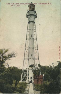 Cape Fear Lighthouse courtesy Southport Times
By 1899, Congress had appropriated "an amount not exceeding $70,000" for a first-order lighthouse on Smith Island (now known as Bald Head Island). By August 31, 1903, the first-order Fresnel lens of the Cape Fear Lighthouse was illuminated and began flashing. At this time, the Bald Head Island lighthouse's fourth-order flashing light was changed to a fixed white light so that it was discernible from the new Cape Fear Light.
The tower continued to operate until it became outdated. The tower burned a fuel oil that had to be brought over from Southport on a tender, and then hauled three-miles by mules to the station. It also still employed the weights to rotate the apparatus which had to be cranked by hand. The tower was simply not economically feasible to operate and would need to be replaced.
By the mid-1950s, a plan was devised to replace the aging lighthouse. The location of the lighthouse would be on Oak Island on property already owned by the United States Coast Guard. In order to ensure the stability of the tower, the base sits upon twenty-four concrete-filled pilings buried sixty-seven feet deep. The pilings are then capped off by a thirty-foot wide by three-foot deep octagonal concrete base upon which the 153' tower was built. This allows it to withstand three-inches of sway during a 100-mph gale. Two Marine Corps heavy-lift helicopters lifted the eleven-foot-tall lantern frame into place to top the tower off.
As the whole structure is constructed of concrete with walls are eight-inches think. While the concrete was being pumped into the forms, the color was mixed in. The bottom forty-feet had natural gray pigment mixed in with the Portland cement, the middle fifty-feet had white pigment mixed in with concrete along with white quartz aggregates, and the top fifty-two feet had black pigment mixed with the concrete. The finished result is a unique day mark that is maintenance free.
The interior of the tower is unique in that unlike classic lighthouses, there are no circular steps. The modern tower features eight landings and a series of ship's ladders to reach the top. There are several photos on Flickr showing the interior. You can view them here and here.
Illumination is provided by two banks of lights, each with four sets of lights and reflectors. The bottom bank contained thirty-six-inch reflectors that housed 2500-watt mercury bulbs. The top bank contained the smaller twenty-four-inch reflectors and 100-watt quartz bulbs. This system was employed from 1958 to 1962 which made it the second brightest in the world, second to the Creac'h Lighthouse in France.
As the mercury bulbs were difficult and expensive to maintain, they were replaced in 1963 with four 1000-watt GE halogen lamps that produced 2.5 million candlepower. The flash is visible twenty-three miles out to sea. Today, the Sullivan's Island Lighthouse in South Carolina is brighter, but the Oak Island Lighthouse still ranks as one of the brightest in the United States.
On the night of May 15, 1958 Captain Charles Swann, the last keeper of the Cape Fear Lighthouse, threw the switch to bring the lights to life. Although the tower was manually operated for many years from the adjacent Coast Guard station, it has since been automated.
On February 1, 2002, the nearly 11,000-square-foot Coast Guard building adjacent to the lighthouse started on fire. The building housed the station's radio command center, barracks for some personnel and administrative offices. The build was a complete loss, and damaged a nearby garage. A new Coast Guard operations center was constructed and opened in July of 2004.
The Town of Caswell Beach took ownership of the lighthouse in a ceremony on October 18, 2004. Unlike many historic lighthouses, the Oak Island wasn't transferred under the National Historic Lighthouse Preservation Act of 2000 as the tower isn't old enough to qualify. Instead, the tower was transferred under the Federal Lands to Parks program.
Today, the grounds are open year round to visitors with on-site thirty-minute parking from dawn to dusk. Tours can be scheduled up to two weeks in advance with the Friends of Oak Island Lighthouse volunteer staff.
Reference:
- Lighthouses of the Carolinas - A Short History and Guide, Terrance Zepke, 1998.
- Annual Report of the Light House Board, U.S. Lighthouse Service, Various years.
- America's Atlantic Coast Lighthouses (6th edition), Jeremy D'Entremont, 2005.
- "Town Takes Ownership of Oak Island Lighthouse in North Carolina," Jeremy D'Entremont, Lighthouse Digest, January/February 2005.
- "Bringing Home the Light," Kim Gottshall, Lighthouse Digest, June 2009.
- "Oak Island Station Destroyed in Fire" None Listed, Lighthouse Digest, April 2002.
- Oakislandlighthouse.org website.
- "Coast Guard station burns - No one injured in Oak Island blaze; lighthouse unharmed" Sherry Jones, Morning Star, February 1, 2002.
Directions: From Wilmington, NC, take Route 133 south for about 30 miles. This will end at Route 211. Make a right onto Route 211 and head up for a short distance. At this point, Route 133 will pick back up again. Follow this for another 4 miles or so to Caswell Beach. Follow Caswell Beach Road for a short distance and you will see the lighthouse on the left-hand side of the road.
Access: Lighthouse grounds are open year round. Oak Island Lighthouse Volunteers offer climbing tours. Tours must be made in advance. More information is available on their website: oakislandlighthouse.org.
View more Oak Island Lighthouse picturesTower Height: 153.00'
Focal Plane: 169'
Active Aid to Navigation: Yes
*Latitude: 33.89280 N
*Longitude: -78.03500 W
See this lighthouse on Google Maps.