Tinicum Rear Range Lighthouse
Billingsport, New Jersey - 1880 (1880**)


History of the Tinicum Rear Range Lighthouse
Posted/Updated by Bryan Penberthy on 2011-03-23.
The federal government acquired 4.8 acres of land along the Delaware River on February 28, 1880 for establishing a set of range lights to guide ships up and down the river. The tower, constructed of iron, with a hexagonal skeletal framework rises 85 feet with a focal plane of 109 feet. The tower housed a fifth order Fresnel lens which displayed a fixed red light that was visible for 8.5 nautical miles, which first displayed on December 31, 1880. The front range lighthouse was a frame dwelling with an attached tower located about 5/8 of a mile southwest of the Tinicum Rear Range Lighthouse. However, this would change over the years as the front range would need to be realigned with shipping channel changes.
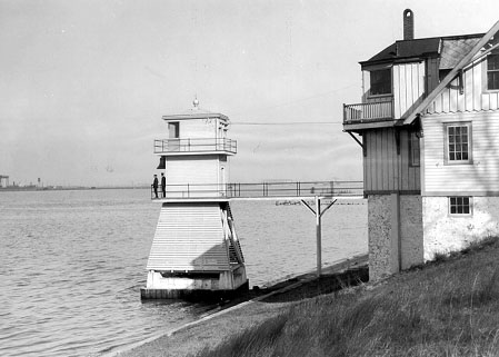 Tinicum Front Range Light (Courtesy Coast Guard)
The Tinicum Island Rear Range Lighthouse with its skeletal framework is somewhat unique in that it has a metal neoclassical pavilion at its base which was used as an oil room and it also has a unique wood-lined closet at the watchroom level. The wood curves to match the circular outer walls of the watchroom. These two unique features are what set this tower apart from the several other skeletal towers in the Delaware River area, such as Finn's Point Rear Range Lighthouse.
Just across the Delaware River in Essington, Pennsylvania sat a twin to the rear range light, the Schooner Ledge Rear Range Lighthouse. The tower was an exact replica of the Tinicum Island Rear light. In fact, the two pairs of range lights were set up to work together in that a ship could pass from one set of range lights to the other in deepwater.
;)
The Tinicum Island Front and Rear Range Lights were also set up to work with the Fort Mifflin Bar Cut Front and Rear Range Lighthouses, which were also constructed the same year in Billingsport. In fact, the Fort Mifflin Bar Cut Front Range and the Tinicum Island Front Range Light were actually the exact same tower. The Mifflin Range Lights pointed upriver, while the Tinicum Range Lights pointed downriver.
;)
Most of the land that the Fort Mifflin Rear Range Lighthouse stood on was sold off to the Vacuum Oil Company. By 1953, the old wooden tower was torn down, being replaced with a more maintenance friendly steel skeletal tower. The area where the rear tower once stood is on the grounds of the oil refinery. The front range light was also replaced with a steel skeletal tower at some point. The Schooner Ledge Rear Range Lighthouse was replaced with a light on a pole in 1915. At this time, the lighthouse was dismantled and stored for several years. It was shipped to Wisconsin in 1919 and would later become the Michigan Island Lighthouse.
The Tinicum Island Rear Range Lighthouse had several outbuildings which give details of what life might have been like for the keeper and his family. In addition to the keeper's dwelling, there was an 18' x 26' barn with a fenced in area to the rear. Other farm like amenities included a cow shed, a 150' x 150' garden, and a poultry house. Also on site was an 8' x 12'oil house and a privy. Before the area around the tower was developed and a water hook-up was available, the keeper would collect water in a 3,700 gallon cistern in cellar of the dwelling, or use the 33 foot deep well on site.
Reading reports of the Lighthouse Board show that the visibility of the rear range was continually a problem. The 1882 Annual Report of the Light-House Board reported that to increase its use as a day mark, a large disk was erected above the tower:
...a prominent day-mark was placed in the top of the iron tower, consisting of an iron disk, 4 feet in diameter, with open horizontal spaces, placed on top of a staff. The height of the disk above the roof of the lantern is 17 feet. The staff is placed on the lantern gallery, back of the lantern, on range, and the whole affair is painted black.
Trees would also cause problems. Within twenty years of the construction of the lighthouse, many trees in the area would be obscuring the rear range light. At first, the Lighthouse Board raised the day mark and additional 18 feet to make it 35 feet above the tower. This sufficed for a few years until 1902 when the Lighthouse Board had to take action. Permission was given to the Lighthouse Board to trim back seventeen poplar trees in Lincoln Park on average of 30 feet. This seems to have fixed the problem as it doesn't turn up in later year's Lighthouse Board reports.
At some point, the keeper's dwelling was vacated. Over the years it fell into disrepair. However, it is unclear as to when the dwelling was torn down. I am also unclear as to when the lighthouse was automated. The Coast Guard's website lists it as 1967, however, it is speculated that the keeper's dwelling was torn down in 1950s. If this is true, then it could be that the keeper resided at the front range light and made the short trek to the rear range? If you know any of these dates, please feel free to contact me. The area around the tower now houses baseball diamonds for the town. The tower is open for climbing. Check the Tinicum Rear Range Lighthouse Society's website for dates.
Reference:
- Annual Report of the Light House Board, U.S. Lighthouse Service, Various years.
- America's Atlantic Coast Lighthouses (6th edition), Jeremy D'Entremont, 2005.
- Tinicum Rear Range Lighthouse website.
- Guiding Lights of the Delaware River & Bay, Jim Gowdy & Kim Ruth, 1999.
Directions:This lighthouse is between Second and Third Streets in Billingsport, north of Paulsboro. From Route 44 (West Broad Street) in Paulsboro, head north on North Delaware Street. Make a right and head north on Billings Ave to Second Street. Make a right onto Second Street, and turn into the baseball diamond parking lot.
Access: Grounds open. Tower open on scheduled dates. Check the http://www.tinicumrearrangelighthouse.org for more information.
View more Tinicum Rear Range Lighthouse picturesTower Height: 85.00'
Focal Plane: 109'
Active Aid to Navigation: Yes
*Latitude: 39.84700 N
*Longitude: -75.24000 W
See this lighthouse on Google Maps.