Gary Harbor Breakwater Lighthouse
Gary, Indiana - 1911 (1911**)

History of the Gary Harbor Breakwater Lighthouse
Gary, Indiana was a city that was envisioned by Elbert H. Gary, a former judge, and the chairman of the United States Steel Corporation. Realizing that most expansion at the turn of the century was occurring in the Midwest, he set his sights on the area around Chicago.
What he found was an area perfect for the production of steel just south of Chicago in the state of Indiana. It had access to the Great Lakes, was crossed by several major rail lines, was largely uninhabited, and was less than twenty-five miles from the major metropolitan area of Chicago. With all of these benefits, the creation of a major steel mill at this location would still be a major undertaking.
To do this, the United States Steel Corporation would form two companies. The Indiana Steel Company would build the steel plant while the Gary Land Company would build the housing and city to support the plant. Things all kicked off in 1906, starting in March with the first survey for the United States Steel Corporation. Within a week, construction was started on Gary Works, which would become the first mill. By April, the survey for the town was started. By July, the town had opened a post office and had been incorporated as a town. The population of Gary in June of 1906 was 334.
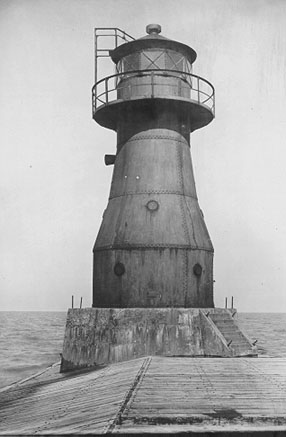 Gary Breakwater Lighthouse (CG)
By 1907, construction of Gary was in full swing. Many ancillary buildings were being constructed in the town such as schools, churches, a hotel, and a bank. Also, the Pennsylvania Rail Road had scheduled a regular stop for Gary in their time tables. By November of 1907, construction of a harbor for the town was already in process. Things were looking good and the population had exploded. By early December the estimated population of the town was 10,000.
Given that Gary, Indiana had no natural harbor to expand or build upon, the United States Steel Corporation had to build one from scratch. They started with two parallel piers spaced two hundred and fifty feet apart which extended out into the lake some two thousand feet to a depth of twenty five feet. Then parallel to the shore, they extend one thousand feet to the east and two thousand feet to the west, behind which was partially back-filled to increase land area. At this time, the United States Steel Corporation had spent about $1.2 million dollars to get the harbor to this point.
Given the harbor was pointing north, any ships in the harbor or trying to enter the harbor at the time of a storm would be affected by the waves of the open lake. Since this was less than ideal, the United States Steel Corporation petitioned the U.S. Government for the creation of a breakwater for the harbor to provide protection from the open lake. However, W. H. Bixby of the U.S. Army Corps of Engineers expressed concern over the government's funding of the breakwater construction. His concern was that the harbor under development was on private property for exclusive use of one company. With that, he felt that the use of public funds for the benefit of a private company could not be warranted.
A survey was ordered on January 4, 1908 by A. Mackenzie, Chief of Engineers, U.S. Army and approved two days later by the Assistant Secretary of Way, Robert Shaw Oliver. The report came back on February 24, 1908 with the determination of the location and the costs that would be associated with the construction of a breakwater for Gary Harbor.
What W. H. Bixby of the U.S. Army Corps of Engineers pointed out was that since the Indiana Steel Corporation extended their piers out further into Lake Michigan to reach deep water rather than the costlier option of dredging to increase the depth closer to shore, the cost of the proposed breakwater would be considerably higher. But what he proposed was an L-shaped structure extending out from the Indiana Steel Company's bulkhead to create a basin of about eighty-five acres. He estimated the cost of the breakwater to be about $1.14 million and the annual maintenance of about $10,000.
By July, the port at Gary was in use sans the breakwater. The first shipment of ore came in on July 23, 1908 aboard the freighter Elbert H. Gary amidst a crowd of several thousand onlookers, to which samples of ore were distributed.
The breakwater was approved by the Army Corps of Engineers in March of 1910. Construction was largely completed by the end of 1910 with only the final concrete cap needing to be applied in the spring of 1911. While the breakwater was under construction, a foundation was sunk at the end for a lighthouse, which would be constructed the following year.
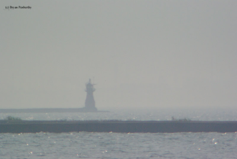
By July of 1911, the lighthouse, constructed out of steel plates, standing thirty feet tall was complete. It exhibited its white light which was powered by acetylene for the first time on July 5. It housed a sixth order Fresnel lens and its signature was two flashes every four seconds which was visible for about thirteen and one-half miles into Lake Michigan.
The lighthouse is still in use today as is the Gary Works steel plant. However, the light has been moved outside of the tower and placed atop of the lantern room. The actual light inside the tower is a standby and only used when the main light fails. Acetylene is no longer used as the fuel, having been replaced by electricity many years ago.
I am not too sure that this lighthouse ever fell under the jurisdiction of the United States Lighthouse Service. From what I have read, it said that maintenance of the lighthouse was provided by the United States Steel Corporation.
Directions: The land around the lighthouse is private property, therefore the best views are from a boat. I used a 1000mm telephoto lens and took these photos from Marquette Park. To get to Marquette Park, follow North Lake Street to the end. Once in the park, look to the west and you will see the lighthouse off in the distance.
View more Gary Harbor Breakwater Lighthouse picturesTower Height: 30.00'
Focal Plane: 40'
Active Aid to Navigation: Yes
*Latitude: 41.63100 N
*Longitude: -87.32000 W
See this lighthouse on Google Maps.