Cape Disappointment Lighthouse
Ilwaco, Washington - 1856 (1856**)

History of the Cape Disappointment Lighthouse
Posted/Updated by Bryan Penberthy on 2017-08-07.
By the mid-1800s, the Columbia River had become a key transportation route, but with one big problem - crossing the bar from the Pacific Ocean into the Columbia River. Due to the number of ships that foundered trying to cross, the area is known as "The Graveyard of the Pacific." To mark the river's entrance, the Lighthouse Board established the Cape Disappointment Lighthouse in 1856.
For several centuries many explorers had searched for the elusive "River of the West" or the "Northwest Passage." But by the late 1700s, explorers of several nationalities would begin closing in on it. Portuguese explorer and navigator Don Bruno de Heceta made one of the first accounts of the Columbia River.
Bruno de Heceta explored the Pacific Northwest in 1775, and while charting the area, he thought he had found the mouth of a large river. He recorded in his ship's log on August 17, 1775:
"The currents and the expanse of water made me believe it is the mouth of a large river of a passage to some other sea."
As part of his crew was lost in a skirmish with Indians on the Olympic Peninsula and the remaining crew weak with scurvy, de Heceta decided not to risk entering the river with his only remaining long boat. Nevertheless, he anchored off the mouth of the river that night and reassessed the situation in the morning. The following morning he noted:
In his logs, he noted and named several prominent capes of the Pacific Northwest - Cape San Rogue, which today is Cape Disappointment, Cape Frondoso, which is today North Head, and Cape Falcon, which today is Tillamook Head.
The following year, Captain James Cook navigated the Pacific Northwest, and during that time, he passed both the Straights of Juan de Fuca and the Columbia River, without finding either.
Several years later, British navigator and fur trader, Captain John Meares located de Heceta's Cape San Rogue on July 6, 1788. Experiencing high seas, and looking for an escape, they approached the elusive river, but at the time, Meares couldn't tell if it was a river or not. Because of this called the body of water "Deception Bay" and named the headland "Cape Disappointment" to reflect his feelings.
In his journal, he penned the melancholy words:
"...Disappointment continued to accompany us...We can safely exert that no river San Rogue exists."
Captain George Vancouver, a British officer of the Royal Navy, anchored off the Columbia for two days, and came to the same conclusion of Captain Meares - there was no river.
It would be an American merchant sea captain named Robert Gray that would provide the name Columbia River. On the evening of May 11, 1792, Captain Gray's men had found a safe channel and entered the river. As they were sailing upriver, Gray named the river "Columbia" after his ship, the Columbia Rediviva.
Gray and his men landed near present day Chinook, Washington and proceeded to trade with the Indians. During this time, he claimed the river and surrounding areas for the United States. Although land disputes between the U.S. and Britain continued for several decades, both countries signed the Oregon Treaty on June 15, 1846, which designated the border at 49° north.
The U.S Coast Survey sent Lieutenant William P. McArthur to examine the West Coast in 1849. During his survey, he would recommend construction of eight lighthouses. Having made it to Oregon by June of 1850, he called the Cape Disappointment headland Cape Hancock; a name that would be used until about 1870.
Before the recommendation of a lighthouse, locals placed a white flag on the headland to mark the river's entrance. Soon after, locals trimmed up several trees to show a "broom top." Mariners would line the trees up to navigate through the deepest part of the channel.
An Act of Congress dated August 14, 1848, officially established the Oregon Territory, which was made up of what is today, Oregon, Washington, and Idaho, as well as parts of Wyoming and Montana.
The same act requested $15,000 for the construction of lighthouses at Cape Disappointment and New Dungeness, as well as buoys to mark the mouth of the Columbia River and the approach to the harbor at Astoria.
It doesn't appear that the government ever used these funds as a little over two years later, on September 28, 1850, a separate act requested $53,140 for the same two lighthouses, and twelve iron buoys to mark the entrance to the Columbia River. The following year, the U.S. Lighthouse Establishment requested an additional $3,000 for fog signals at Cape Disappointment, Cape Flattery, and New Dungeness.
Gibbons & Kelly of Baltimore, Maryland won the contract to construct multiple West Coast Lighthouses. The locations selected were San Diego, Point Conception, Point Pinos, the Farallon Islands, Alcatraz Island, and Fort Point.
Added onto the contract after the fact were two additional lights - the Humboldt Harbor Lighthouse in California and the Cape Disappointment Lighthouse in Washington.
Gibbons & Kelly loaded the supplies for all eight West Coast lights onto the Oriole except the materials needed for the exterior walls, which they were to source locally. By early 1853, the Oriole had arrived in California and construction began on several of the lights concurrently.
The Oriole reached the mouth of the Columbia River in mid-September 1853. However, conditions were unfavorable to cross the bar. After waiting out rough seas for eight days, the Oriole, under the command of Captain Lewis Lentz picked up pilot Captain Flavel.
With a southwest breeze, the Oriole began crossing the bar on September 18, 1853. Within two hours, the winds dropped off, leaving the vessel at the mercy of the seas. As the bark was heavily laden, it was riding deep in the water.
The force of the incoming and outgoing waves caused the ship to strike the bottom repeatedly. The stress of the hits caused the hull planking to pull free, and soon the rudder pushed up through the decking allowing sea water to flood in.
The amount of water pouring in was too much for the pumps to handle. The only option was to abandon ship. All 32 aboard made it into small boats, where they proceeded to float overnight until being rescued the following dawn by the pilot boat California.
The Oriole eventually slipped off the reef, turned over on its beam ends, and sank, taking with it the necessary building supplies needed for the Cape Disappointment Lighthouse. The sinking caused a major setback as it would be 1854 before additional supplies made it to the cape.
To safely unload the supplies, the Lighthouse Board created a landing area in the placid waters of Baker Bay. Mules and other beasts of burden were utilized to grade a road to the summit over which all supplies traversed. Soon construction progressed.
As the tower was under construction, the newly established Lighthouse Board adopted the Fresnel lens to replace all existing reflector systems. The Lighthouse Board notified Gibbons & Kelly of the change stating that they would ship Fresnel lenses would for all eight West Coast lighthouses.
In some cases, lanterns already completed that could not accommodate the larger Fresnel lens would have to be torn down and rebuilt. The diameter of the Cape Disappointment Lighthouse wasn't broad enough to fit a first-order Fresnel lens and therefore would require rebuilding.
The typical design of the West Coast lighthouses was a 1½-story dwelling that incorporated a round tower in the center of the roof. This model worked well in all but two locations - Cape Disappointment and the Farallon Islands. As neither site could accommodate that design, towers with stand-alone dwellings were built.
When completed, the tower was 53 feet tall but had a focal plane of 220 feet above sea level due to the headland. Inside the lantern was a first-order Fresnel lens manufactured by Louis Sautter & Co. of Paris, France, which Keeper John Boyd placed into service on October 1, 1856.
The station had a 1,600-pound fog bell, but it was found to be ineffective due to its location and the roar of the surf. In a letter to Major Hartman Bache, the twelfth district engineer, Keeper Boyd sent the following:
"It is not rung when we can see beyond the outer breakers which are about three miles distant. I presume that it is proper to say here that it cannot be heard half that distance, except if it is perfectly calm, nor can it be heard in the channel opposite the tower with a light breeze blowing from the southward..."
Bache responded with the following:
"Was aware that the bell could not be heard very far. The height and form of the head, taken in connection with the direction of the wind, no doubt principally explains this - the roar of the surf also has something to do with it."
Due to its inefficiency, the Lighthouse Board had the fog bell discontinued. The date of discontinuance is unclear as one document listed it as July 12, 1881, and the other listed it as September 1, 1881. The Lighthouse Board had it transferred to the West Point light station near Seattle.
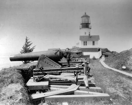 Cape Disappointment Lighthouse with gun battery (CG)
With the onset of the Civil War, the War Department built Fort Canby to protect the mouth of the Columbia River. Construction started in August 1863, and occupation took place by April 1864. Mounted in front of the lighthouse was the Lighthouse Battery, which contained two 8", four 10" and one 15" Rodman smoothbore gun, nicknamed "Betsy."
Keeper Boyd complained to the district engineer in February 1865 that when the Army fired the weapons, the concussion from the blast had blown out the windows of the tower. Although he had requested the station be relocated, his request was denied. Instead, the engineer advised Boyd to open the windows when the Army fired the guns.
Damage to the windows in the tower weren't the only issues that gun batteries caused. In July 1871, a gun blast shattered the old fog bell frame. The Lighthouse Board had a new fog bell house built in August that year.
Although Keeper Boyd had requested a larger dwelling for himself and his assistants as early as the 1858-1859 timeframe, it would take until spring 1865 before an addition would be built. Unfortunately, Keeper Boyd would never get to enjoy the addition as he died on duty October 26, 1865, before it was completed.
Apparently the additional space didn't help the cramped living quarters as the Lighthouse Board stated in the Report of the Secretary of the Treasury on the State of the Finances for the Year 1867 that the keeper's dwelling was "deemed too small and inconvenient for the purposes of a first-order light." It would take a few years, but in August 1871 construction was started on a new double frame dwelling, which was completed in December that year.
The Lighthouse Board continued to upgrade the station throughout the years. They had a new oil house erected in 1873, and a new cistern for the keeper's dwelling in 1876. Twenty acres of pasture land were also enclosed that year. A new barn was built in 1890.
In 1889, the Lighthouse Board reported that a new walk, 1,350 feet long was laid from the keeper's dwelling to the tower and a new galvanized iron oil house was built. That same year, it was reported that the Cape Disappointment Lighthouse was "inadequate for the purposes of commerce and navigation" as it was hard to see when approaching from the north.
The Lighthouse Board recommended establishing several new first-order lighthouses along the Pacific Northwest including one at Gray's Harbor, Destruction Island, as well as a new first-order lighthouse on North Head, roughly two miles northwest of the Cape Disappointment Lighthouse. The Annual Report of the Lighthouse Board for the year 1889 had the following recommendation:
North Head, Cape Disappointment (Hancock), sea-coast of Washington - The present light at Cape Disappointment is inadequate for the purposes of commerce and navigation. It is believed that if North Head is marked by a first-order light, and the proposed light-stations at Gray's Harbor and Destruction Island are completed, that the Pacific coast will be well supplied with lights of the first order from Cape Flattery to Tillamook Rock. Proper measures should be taken for the establishment of a first-order light at North Head. This, it is estimated, will cost $50,000. It is recommended, therefore, that this sum be appropriated for this purpose. When this light is established, the first-order light at Cape Disappointment will no longer be necessary, and it is proposed to then reduce it to a light of the fourth-order. It will then be of sufficient power to benefit vessels close to the bar outside and vessels in the Columbia River.
The same request showed up in the Annual Report for several years. Congress finally funded the North Head Lighthouse by appropriating $25,000 on August 18, 1894, and an additional $25,000 on March 2, 1895.
In early January 1898, the Lighthouse Board removed the first-order Fresnel lens from the Cape Disappointment Lighthouse and established a temporary lens-lantern on January 15, 1898. A fourth-order Fresnel lens manufactured by Barbier and Benard was then installed on February 17, which showed alternating red and white flashes of 15-seconds.
The North Head Lighthouse was completed on April 10, 1898. The first-order Fresnel lens was installed and placed into service on May 16, 1898.
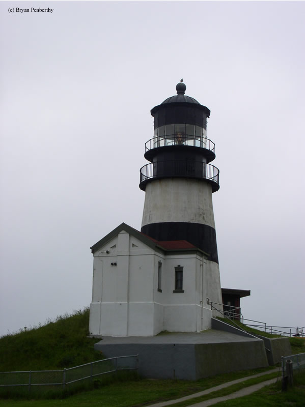
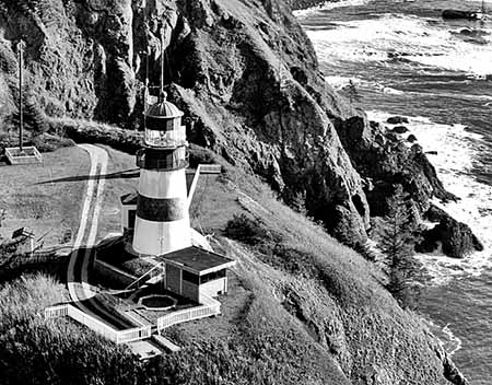 Cape Disappointment Lighthouse with black band (CG)
In the early 1930s, the U.S. Lighthouse Service added a distinctive black horizontal band around the midsection of the Cape Disappointment Lighthouse to help mariners distinguish it from the North Head Lighthouse.
Like most coastal lighthouses during World War II, the Coast Guard extinguished the Cape Disappointment Lighthouse and North Head Lighthouses. Unaware of the mandatory blackout and in distress, the Mauna Ala bound for Honolulu returned to the mainland where it ran aground on the south entrance to the Columbia River.
The Coast Guard was able to rescue all passengers, but with the loss of a cargo of Christmas trees. After that incident, most coastal lights were relit. However, some ranges were reduced, and there were still occasional blackouts.
In November 1965, the Coast Guard had made a recommendation to discontinue the Cape Disappointment Lighthouse. In doing so, they issued a Notice to Mariners stating their intentions indicating that the mouth of the Columbia River was marked adequately with range lights and the Columbia River Lightship. The Columbia River Bar Pilots objected to the proposal and today the "Cape D" Lighthouse is still in service having been automated in 1973.
Today, the first-order Fresnel lens that was installed in both the Cape Disappointment and North Head Lighthouses is on display at the Lewis and Clark Interpretive Center at Cape Disappointment State Park.
Reference:
- Annual Report of the Light House Board, U.S. Lighthouse Service, Various years.
- "Cape Disappointment Light Station," Wayne Wheeler, The Keeper's Log, Spring 2005.
- Pacific Coast Survey of 1849 and 1850, Lewis A. McArthur, 1915.
- Lighthouses of the Pacific, Jim Gibbs, June 1, 2003.
- Oregon's Seacoast Lighthouses, Jim Gibbs & Bert Webber, June 2003.
Directions: From the Town of Ilwaco, Highway 101 becomes Spruce Street. Head into Fort Canby State Park / Cape Disappointment State Park on North Head Road. Follow the signs to the Lighthouse parking area. There is a hiking path which leads to the lighthouse. If I remember correctly, it is about a ½ to ¾ mile trail. The North Head Lighthouse is in the same park.
Access: The tower is owned by the Coast Guard. Grounds open. Tower closed.
View more Cape Disappointment Lighthouse picturesTower Height: 53.00'
Focal Plane: 220'
Active Aid to Navigation: Yes
*Latitude: 46.27585 N
*Longitude: -124.05220 W
See this lighthouse on Google Maps.