Diamond Shoals Lighthouse
Buxton, North Carolina - 1967 (1824**)

History of the Diamond Shoals Lighthouse
Posted/Updated by Bryan Penberthy on 2013-04-07.
The area around Cape Hatteras and the Diamond Shoals has an ominous name, "The Graveyard of the Atlantic." The name comes from the sheer number of vessels that have been lost in the area, over 2300 since the early 1500s.
There are two currents or "rivers" that flow up and down the east coast of the United States. The cold Labrador Current flows from the north to the south, and the warmer Gulf Stream Current flows up from the south. These two currents "collide" just off shore from Cape Hatteras in an area known as Diamond Shoals. The collision forms very turbulent waters and a large expanse of shallow sandbars extending some 14 miles offshore.
In the late 1700s, two lighthouses were approved in the area. Shell Castle Island Lighthouse would provide safe passage to Ocracoke Harbor. And the Cape Hatteras Lighthouse would mark the dangerous Diamond Shoals. Both lighthouses were completed in 1803.
 Diamond Shoals Light Tower (C.G.)
The lighthouse was deemed a failure almost from the beginning. Its lamps were too weak to cast its beam out past the shoals, and mariners often complained that they passed the point without ever seeing the light. Lieutenant H. J. Harstene of the U.S. Navy had recommended "if not improved, had better be dispensed with, as the navigator is apt to run ashore looking for it." As a day mark, it was also ineffective. The tower was never painted, so it retained the brown color of the sandstone which often blended into the shore.
In an attempt to supplement the lighthouse, the federal government anchored a light ship at the outer edge of Diamond Shoals in 1824, fifteen-miles off Hatteras Island. The large ship bore the name Cape Hatteras and had two lanterns fixed aloft masts. The ship was only on station for three years before being blown ashore during a gale causing irreparable damage.
Although numerous upgrades were made to the lighting system at Cape Hatteras over the years, it never really provided adequate protection for mariners. Much needed changes would come in 1854 when Congress appropriated $15,000 to increase the height of the Cape Hatteras Lighthouse as well as install a newly adopted first-order Fresnel lens. To make it an effective day mark, the lower seventy feet of the tower was whitewashed and the rest was painted red.
That same year, the Lighthouse Board's chief engineer noted that the structure was deteriorating. Sand had been blown away from the base of the tower exposing several feet of the foundation; expanding cracks, aging wooden stairs, and degraded iron work were all listed in the report. With the cost of repairs prohibitive, the district engineer recommended a new lighthouse for Cape Hatteras. On March 2, 1867, Congress appropriated $75,000. Over the next two years, additional appropriations brought the total to $167,000.
The Lighthouse Board hired accomplished lighthouse builder Dexter Stetson of Maine to supervise the project. Construction started in December 1868 and was modeled after William H. C. Whiting's design for the Cape Lookout Lighthouse to the south. Since the sea was encroaching on the site of the 1803 lighthouse, the Lighthouse Board selected a site that was "above the highest level of the sea and so far removed from the waterline as to render it safe from encroachment from the sea." The site was located about 600 feet further inland from the 1803 tower and 1,600 feet from the high water mark.
The 193-foot tower was completed by September of 1870 and the lantern was installed that November. In December, the lampist arrived on site to install the first-order Fresnel lens made by Henry Lapaute of Paris, France. The keeper lighted the lamps, exhibiting the beacon for the first time on December 16, 1870. The old lighthouse was torn down in February of 1871.
In order to differentiate the Cape Lookout, Cape Hatteras, and Bodie Island lighthouses from each other as a day mark, the Lighthouse Board ordered a unique color scheme for each on April 17, 1873: "Cape Hatteras tower will be painted in spiral bands, alternately black and white. Cape Lookout tower will be checkered, the checkers being painted alternately black and white. Body's [sic] Island tower is now painted black and white horizontal bands."
Although the new 1870 Cape Hatteras Lighthouse did a good job marking the area, during inclement weather, the range of the light was impacted. Starting in 1882, there were numerous petitions from insurance companies, merchants, and masters of vessels coming in to the Lighthouse Board asking that either a light vessel or an offshore lighthouse mark the Diamond Shoals.
Henry F. Picking, Commander of the U.S. Navy responded to the request stating that it would be impossible to keep a light ship on location as the Lighthouse Board had tried to secure whistling buoys with moorings heavy enough to hold a vessel in place, and that the moorings were unsuccessful.
He went on to state that if a light vessel was to go adrift during a gale; it would inevitably be lost along with all on board. He did state that he would be in favor of placing a lighthouse on site and instructed the local officers to make the surveys, reports, and recommendations available to the board to allow them to make an informed decision.
Numerous letters between various contractors and Henry F. Picking, Command of the U.S. Navy were sent back and forth. By 1885 the Lighthouse Board had decided to move forward with the establishment of a first order lighthouse on the outer shoal. It would still take several years before a bill was put in front of Congress.
The bill went before Congress in January of 1888 and was approved. Congress appropriated $200,000 with a provision to not exceed $500,000 on March 2, 1889. Bids were put out to advertisement, and were reviewed on July 1, 1890. The lowest bid of $485,000 was accepted, and the contractors, Messrs. Anderson & Barry, agreed to have it ready for lighting on January 1, 1892.
By June of 1891, the 45-foot-tall caisson was completed. On June 28, with three tugs pulling the barge, it left Norfolk, bound for North Carolina. One tug ran into mechanical issues and forced the group to return to Norfolk. After repairs were made, the group had set out again for North Carolina, arriving at 9:30 am on July 1, 1891. After a few problems, the crew was able to place the caisson. A crew vessel arrived with supplies on the afternoon of July 3, and started construction on the caisson the next day, but when the seas started to pick up, work was called off.
A storm arrived on July 8 which carried away machinery, a dredging tube, and the upper portion of the caisson. The Annual Report of the Lighthouse Board dated 1892 had the following entry:
488. Outer Diamond Shoals, off Cape Hatteras, North Carolina - Since the destruction of the caisson on July 8, 1891, reported in the Board's last annual report, no further attempt was made to erect this light-house.
After the failed attempt to sink a caisson in 1891, the Lighthouse Board unwilling to admit defeat. On May 23, 1894, a boring apparatus that the Lighthouse Board had designed left for Diamond Shoals and arrived on site two days later. Once on site, the crew was able to successfully ground the apparatus and attached it to the ocean floor.
The plan was to construct an iron skeletal tower much like the lighthouses of the Florida Keys. On June 4, 1894, the Lighthouse Board instructed an engineer to have plans prepared for an iron tower with attached keeper's quarters, a fog signal, and a hyperradiant lens.
A year later, Julius E. Rettig, the superintendent of construction that had placed the apparatus the previous year arrived on site to examine it. Although the structure had considerable damage, there was no additional settlement. He had furnished the keeper of Cape Hatteras with a telescope and had asked him to report its condition monthly.
By April of 1896, plans were prepared and approved for two different steel skeletal towers. The jobs were advertised and bids were received by June 9. However, by an act approved on June 11, Congress had directed a portion of the appropriation for the construction of a light vessel and that all other funds were returned to the treasury. With the approval of that act, all work on the lighthouse ceased.
Light vessel 69 was completed and delivered to the Lighthouse Depot in Staten Island by Mid-August of 1897. The vessel measured 112-feet long, nearly 29-feet wide, and had a tonnage of 450 tons. The electric plant consisted of two 4-inch double-cylinder engines with generators, capable enough to power the ship as well as power the two electric lights on the mastheads. The vessel was outfitted with a Crosby chime fog signal powered by a steam engine.
Light vessel 69 was towed by the lighthouse tender Maple and arrived at Diamond Shoals around midnight on September 30, 1897. After mooring the vessel in place, the lights were exhibited around 2 a.m.
As there were many important lightships in the fifth lighthouse district including the newly stationed Diamond Shoals light vessel, a recommendation was made for a Relief lightship. The Lighthouse Board requested an appropriation of $80,000 for the vessel.
On March 9, 1898, light vessel No. 71 was brought in from the fourth lighthouse district to relieve light vessel No. 69 which was brought in for examination and repair. It was recommended that the $15,000 provided by Congress on July 7, 1898 be used for those repairs. Light vessel No. 71 continued to mark Diamond Shoals in light vessel No. 69's absence.
Light vessel No. 69 was pressed into service as a lighthouse tender during the start of fiscal year 1899 when the tender Maple was turned over to the Navy for service during the war with Spain. Due to the deep draft of the vessel and its slow speed, it didn't serve this role well. With the conclusion of the war, the light vessel was towed to Baltimore for overhaul and repair.
Light vessel No. 69 returned to Diamond Shoals on November 24, 1898 allowing light vessel No. 71 to return to Baltimore for repairs and maintenance. A heavy southwest gale on January 6, 1899 caused light vessel No. 69 to drag her anchor. The vessel was able to remain on post by running the engine until the gale subsided. On January 8, after the seas settled, the anchor was pulled up and found to be damaged.
To repair the anchor, the vessel returned to the lighthouse house depot in Portsmouth, Virginia. As there were no mushroom anchors available, a 500-pound mushroom sinker was outfitted. Her water tanks were filled, and numerous supplies were furnished before returning to Diamond Shoals on January 12. As there was a heavy fog in the area, the vessel couldn't get a bearing on the Cape Hatteras Lighthouse. After the fog cleared, the vessel was moved into the proper position.
Over the next several months, light vessel No. 69 was dragged off position during several gales. The vessel returned to its proper position when practicable. August 16 would see the Great Hurricane of 1899 move across the Outer Banks. Despite trying to steam against the hurricane, the vessel ended up being driven ashore near the Creed's Hill lifesaving station south of the Cape Hatteras Lighthouse. The Lighthouse Board contracted with Chapman-Merritt Wrecking Company for $15,000 to recover the vessel and deliver her to port where she could be repaired. Light vessel No. 71 took over while No. 69 was being repaired. Light vessel No. 69 returned to Diamond Shoals on September 2, 1900. A new lightship, No. 72, built in 1900, relived No. 69 on February 17, 1901.
 WLV-189 - Diamond Shoals Lightship
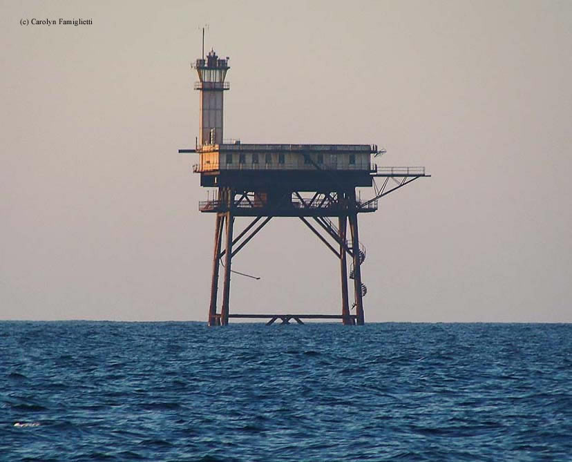
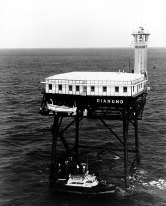
Various light vessels would mark Diamond Shoals until 1966, including LV 114 / (WAL 536), later known as the New Bedford Lightship, when it was replaced with a "Texas Tower," which resembled an oil platform. The tower, which consisted of four steel, concrete-filled piles driven into the ocean floor, was then topped with a square platform which would serve as the living quarters and a helipad. One corner of the platform housed a light.
The Diamond Shoals Lighthouse was automated in 1977. Over the next several decades, the structure would take abuse from the open Ocean. In 1996, the lighthouse would take significant damage from Hurricane Fran, and an inspection would show that it was unsafe to visit by anything other than a helicopter winch. Despite the inherent dangers associated with maintaining the light, its use would continue for another five years before being extinguished in 2001.
The lighthouse sat abandoned for just over a decade before being put up for auction by the General Services Administration. The bid opening date was May 24, 2012, and after all bids were opened, none were accepted. A second auction was set up with a minimum bid of $15,000 with a closing date of August 31, 2012.
The second auction received only one bid. The bid of $17,200 was submitted by Dave Schneider, president of Zap Water Technology, Inc. of Minnesota. Mr. Schneider has plans to restore the tower, and then use it as a center to evaluate new technologies. Currently, access to the tower is limited as the ladders to the tower as missing, and the landing deck can't support the weight of a helicopter.
Note: The lighthouse is private property, please respect this and do not trespass.
Reference:
- Lighthouses of the Carolinas - A Short History and Guide, Terrance Zepke, 1998.
- Annual Report of the Light House Board, U.S. Lighthouse Service, Various years.
- America's Atlantic Coast Lighthouses (6th edition), Jeremy D'Entremont, 2005.
- "Only one bidder enticed by Diamond Shoals light," Sam Walker, The Outer Banks Voice, September 4, 2012.
- "Man pays $20,000 for abandoned light tower," Jack Horan, newsobserver.com, October 7, 2012.
Directions: The lighthouse sits 13 miles offshore from Cape Hatteras in the open Atlantic. The best view would be from a boat, however, very distant views are available from Cape Hatteras.
Access: The lighthouse is private property. There is no access to the lighthouse. Do not trespass.
View more Diamond Shoals Lighthouse picturesTower Height: 120.00'
Focal Plane: 125'
Active Aid to Navigation: Deactivated (2001)
*Latitude: 35.15300 N
*Longitude: -75.29700 W
See this lighthouse on Google Maps.