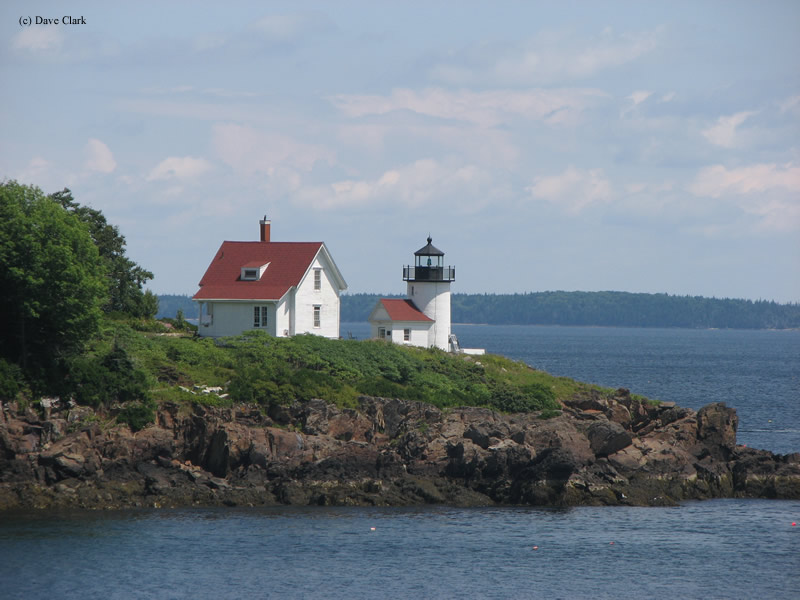
Curtis Island Lighthouse
Camden, Maine - 1896 (1835**)

History of the Curtis Island Lighthouse
Posted/Updated by Bryan Penberthy on 2019-08-12.
Since 1836, a lighthouse has occupied the southern end of a seven-acre island just offshore from Camden, Maine. Today, it is known as the Curtis Island Lighthouse. However, when the government established in 1836, it was known by another name, the Negro Island Lighthouse.
Penobscot Abenaki Indians referred to the area around Camden, Maine as Megunticook, which meant "great swells of the sea." Although Goose River Village, roughly two miles south, was originally part of the Megunticook Plantation and later, incorporated as Camden in 1791, it would split from Camden before the end of the 1800s.
One of the first settlers, James Richards, moved his family from New Hampshire to Bristol, Maine in 1767. Within a year, they had moved to Camden, Maine. While returning from a trip with his family on May 8, 1769, and upon entering Camden Harbor, the ship's African cook pointed to the island at the entrance to the harbor and exclaimed: "Dare, dat's my island!" From that point on, the island became known as "Negro Island."
Several industries, notably lime production, shipbuilding, and ice harvesting, helped Goose River Village and Camden grow quickly. The Citizens of Goose River Village elected to change the town's name in 1852 to Rockport after its emergence as one of the nation's great lime production centers. After a dispute over the cost of constructing a bridge, Rockport officially split from Camden on February 25, 1891.
As the newly formed United States continued to grow, so did the call for granite, lime, and other building materials. Many of the kilns around Penobscot Bay were in full production, which increased shipping traffic. With more vessels on Penobscot Bay, the government erected lighthouses to provide safety.
As Rockland was one of the busiest ports in all of Penobscot Bay, the government erected the Whitehead Lighthouse in 1804 to mark the Muscle Ridge Channel into the bay, followed by the Owl's Head Lighthouse in 1825 to mark the south side of the entrance to Rockland Harbor.
Camden, a little over seven miles north of Rockland, was another crucial area for the production of lime. To safely get vessels into and out of the harbor, Congress appropriated $4,500 on June 30, 1834. The federal government purchased the island from John Dorr of Boston for $400.
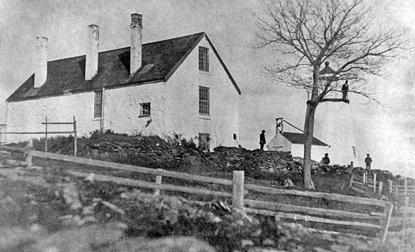 Negro Island Lighthouse with original dwelling (Courtesy National Archives)
Over the next year, several contractors spent time on the island working on the light station. George Gault (sometimes spelled Galt) and mason Oliver A. Andrews built a 20-foot-tall rubblestone tower along with a 3-room, stone keeper's dwelling for a sum of $2,569.
After the tower's completion, Joseph Berry from Georgetown, Maine installed the lighting apparatus for $650. Eight oil lamps and 14-inch reflectors produced a fixed white light which was visible for 10 miles.
Henry K. M. Bower, the station's first keeper, put the lighthouse into service in 1836. As was common at the time, Keeper Bower was allowed to keep animals at the station, which included cows, ducks, and chickens, as well as allowed to cut trees on the island for wood.
Lieutenant Thomas J. Manning was ordered to survey the lighthouses of the first district in 1838. He included an interesting sentence in his report stating, "I herein send you my report and give information as far as the limited time would allow." With that, the brief report stated: "Negro-island light - In very good order."
As it appears that Manning wasn't given enough time to inspect each station in his district, the federal government requested a more thorough report several years later. Engineer Isaiah William Penn Lewis, or as he is more commonly known I.W.P Lewis, visited many stations in 1842 and produced a comprehensive report, which included statements by keepers.
Of the tower, he had the following to say:
Tower of rubble masonry, 20 feet high, laid up in lime mortar, and resting on the natural surface of a sloping ledge; wall cracked from roof to base by the gale of February, 1842; soapstone roof, and leaky.
His report of the keeper's dwelling was more critical:
Keeper's dwelling-house of rough stone, laid in lime mortar; roof shingled; 3 rooms on lower floor, with small cellar, and 3 chambers in the attic; chimneys smoky; no well nor rain-water cistern; buildings badly constructed.
His report went on to document the poor conditions of the lantern and lighting equipment, which included four broken panes of glass, seven reflectors out of perpendicular, and two of the eight reflectors were facing over land. As the light was to mark Camden Harbor, Lewis stated that "one lamp of a proper form is alone required here, instead of eight now used."
Ephraim S. Fly, the keeper of the Negro Island Lighthouse at that time, included the following details regarding the lack of freshwater available to him in his statement dated July 21, 1842:
I have no well of spring water fit for use, and the rain-water cisterns supplied by the contractor who erected the house are all useless; consequently, I am frequently obliged to procure water from the main land.
It would take until 1901 for a new brick cistern to be built in the dwelling.
Although I. W. P. Lewis found the tower leaky in 1842, nothing would be done until 1855 when contractors sheathed the tower in wood and shingles.
The following year, an "improved reflecting apparatus" was installed until a fourth-order Fresnel lens was installed later that year.
Nearly another decade would pass before extensive repairs were carried out on the Negro Island (Curtis Island) Lightstation. The Report of the Secretary of the Treasury on the State of the Finances for the Year 1868 had the following lengthy entry:
23. Negro Island - Dwelling cleansed throughout; all broken glass reset, and sashes repainted two coats; outside wood-work painted, walls repointed, and leaks about window-frames and chimneys stopped; door latches repaired or renewed, as required; storm-houses constructed over back and front doors; kitchen floors relaid; walls and ceilings partially replastered; chimney flue repaired; new cast-iron sink, pump, and pipe put in, and inside wood-work painted two coats; three rooms and passage partially replastered, and walls repapered; three closets built; all inside wood-work of dwelling painted; tower porch whitewashed inside and furnished with a service closet; privy moved to the rear of the dwelling, and plank to it laid; new wood-shed, 10 x 14 in plan, built; boat-house reboarded and reshingled, and fitted with new sills, doors, and fastenings. The boat slip has been repaired with new timbers, rollers, and fastenings. The wharf has been repaired with new planking and cap sills, and a flight of plank steps supplied. Illuminating apparatus examined and repaired; timepiece cleaned.
Another extensive renovation took place in 1874. This entry is from the Annual Report of the Secretary of the Treasury on the State of the Finances for the Year 1874:
28. Negro Island, off Camden Harbor, Maine - The roof of the keeper's dwelling has been reshingled, new saddle-boards put on, chimney repaired, walls repointed, six new windows put in, new gutters and water-conductors furnished, storm-porches repaired, interior plastering, floors, and doors repaired, and all wood-work repainted. The outbuildings have been repaired and painted.
Two years later, in 1876, a 50-foot-long covered way was erected to connect the tower and the dwelling.
By the mid-1870s steamship service between Boston and Bangor were running twice-weekly. This service included stops at many Maine ports, which included Camden. The keeper of the Negro Island Lighthouse was in a unique position to see the steamer in Penobscot Bay and would signal Camden Harbor by hoisting a large ball to the top of a pole. This action would allow the Camden hack drivers, and others to prepare for the steamship's arrival.
By the mid-1880s, the keeper's dwelling was in poor condition. Finally, in 1889, the old rubblestone keeper's dwelling was razed and replaced with a new wood-framed dwelling built upon the same foundation. Contractors also constructed a new barn, boat-house, and boat-slip at that time.
A new oil house was erected in 1894.
In preparation for the construction of a new tower, contractors removed the lens on May 11, 1896, and transferred it to a temporary tower 40 feet east-northeast of the original tower allowing the old tower to be razed.
Mr. Hutchins, a mason from Bristol, Maine erected a 25-foot-tall, round, brick tower in just a few short months. And on July 31, the lens was moved from the temporary tower into the new one.
In October 1896, Contractors added a wooden fog bell tower and a 1,000-pound bell to the station, which the keeper was to ring by hand during thick or foggy weather. The Lighthouse Board notified mariners that this was to go live on or about October 20, 1896.
Publishing magnate, Cyrus H. K. Curtis, frequently summered in Camden, Maine and was a founding member of the Camden Yacht Club in 1906. He went on to serve as the club's Commodore from 1909 until his death on June 7, 1933.
To build a clubhouse for the Camden Yacht Club, Curtis spent $60,000 of his own money, after which he rented the property to the club for a nominal fee. In 1926, he gifted the clubhouse and land to the Town of Camden with the stipulation that its use continued as a yacht club.
Shortly after Curtis's death, his daughter, Mary Louise Bok started a movement to rename Negro Island to Curtis Island, as well as rename the Negro Island Lighthouse to the Curtis Island Lighthouse in memory and honor of her late father. As Curtis was a financial benefactor to many local causes in Camden, the people of the town immediately backed the name change.
After an approval vote by the community, Senator Wallace White sent a letter to George Putnam, Commissioner of Lighthouses, to request the change. Putnam approved the change and then forwarded the request to the United States Geographic Board for their approval, which took place on May 2, 1934.
By 1970, word spread that the Coast Guard was planning to auction off the light station, except the tower. Rather than see the property sold to a private party, three Camden residents traveled to Philadelphia and convinced the Coast Guard to give the property to the Town of Camden.
The Coast Guard automated the lighthouse in 1972 and at that time, replaced the Fresnel lens with a modern optic. The Town of Camden officially acquired the property for use as a public park in 1973, while the Coast Guard retained ownership of the tower.
By the late 1990s, the Coast Guard was looking to disposition the light tower. After a public vote, the town officially acquired the lighthouse in 1998 under the Maine Lights Program, the predecessor to the National Historic Lighthouse Preservation Act of 2000.
Today, the lighthouse has an occulting green pattern welcoming boaters into Camden Harbor just as it did more for more than a century.
Reference:
- Annual Report of the Light House Board, U.S. Lighthouse Service, Various years.
- Various Government Documents, Federal & State Governments, Various dates.
- Annual Report of the Secretary of Commerce, United States, Various.
- Annual Report of the Commissioner of Lighthouses, U.S. Lighthouse Service, Various years.
- Lighthouses of Maine: Penobscot Bay (Lighthouses Treasury), Jeremy D'Entremont, July 9, 2013.
- "Maine Lighthouse Named After Publishing Leader," Timothy Harrison, Lighthouse Digest, August 2005.
- National Register of Historic Places, U.S. Dept. of the Interior, Various.
Directions: The lighthouse sits off shore on Curtis Island. The best view of the lighthouse is from one of the cruises that leave from town. However, distant views are possible from shore. From the Town of Camden, follow Bay View Street south along the shore to the intersection of Beacon Ave. From here, there is a "Curtis Lighthouse Overlook" are nestled amongst the trees where distant views are possible.
Access: The lighthouse and grounds are currently owned by the Town of Camden. Grounds open. Dwelling and Tower are closed.
View more Curtis Island Lighthouse picturesTower Height: 25.00'
Focal Plane: 52'
Active Aid to Navigation: Yes
*Latitude: 44.20136 N
*Longitude: -69.04887 W
See this lighthouse on Google Maps.