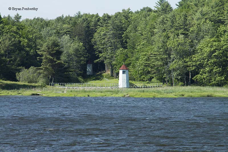
Doubling Point Range (Kennebec River Range) Lighthouse
Arrowsic Island, Maine - 1898 (1898**)

History of the Doubling Point Range (Kennebec River Range) Lighthouse
Posted/Updated by Bryan Penberthy on 2017-02-19.
When navigating the Kennebec River, there comes a point, just before reaching the city of Bath, where mariners need to make two 90-degree turns. To ensure that vessels were in the center of the channel, the Doubling Point Range Lights, sometimes known as the Kennebec River Range Lights, were established in 1898.
Bath, Maine had played a part in many industries including lumber, iron, brass, ice, and coal, but it would be renowned for its shipbuilding. Started in 1743 by Jonathan Philbrook and his two sons, shipbuilding would take Bath by storm. At one point, there were more than 200 shipbuilding firms operating in the area, and by the mid-19th century, it was the nation's fifth largest seaport.
This put a lot of traffic on the Kennebec River. Although the federal government did establish the Seguin Island Lighthouse and the Pond Island Lighthouse, both near the mouth of the Kennebec River, there were no federally maintained lights for navigation on the river.
Private companies had maintained lights at turning points in the river, but it would take until 1892 before the Lighthouse Board would recommend any federally maintained lights for the Kennebec River. The Lighthouse Board made the following case in their Annual Report of the Lighthouse Board:
Perkins Island, Squirrel Point, Doubling Point, Ames Ledge light-stations, Kennebec River, Maine - There were 3,137 arrivals of vessels in this river during the year, not counting the steamers which ply daily. The steamers Kennebec, 1,052 tons, and Sagadahoc, 1,413 tons, made ninety-six round trips each from Gardiner to Boston. Other passenger steamers ply on the river from Bath to Augusta, Boothbay and Popham Beach, and intermediate places. The number of passengers carried was 232,150.
The entry went to advise that several lighthouses be established along the river, and recommended the following set of lights to mark both of the turns at Doubling Point:
At Doubling Point a red lens-lantern light, showing up and down the river, with a fog bell, and one-half mile east from the point, white range lights, not less than 500 feet apart, to mark the channel from Ram Island to Fiddlers Reach, at an estimated cost of $6,300.
The other lights that were proposed by the Lighthouse Board were to be located at Squirrel Point, Perkins Island, and Ames Ledge. The Lighthouse Board stated that all four lights could be built for $16,725.
It would take a few years, but on March 2, 1895, Congress appropriated $17,000 for establishing lights on the Kennebec River. The light at Ames Ledge, north of Bath, was the first to be established on May 11, 1896.
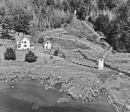 The Range Lights circa 1975 (Courtesy Coast Guard)
The others took a little more time, but by 1897, all titles had been obtained, plans had been prepared, and contracts had been made. By February 1898, the Doubling Point Range Lights were largely complete.
Erected were two frame towers, 235 yards apart. The front tower stood 21 feet tall, with the rear being only 13 feet tall. A two story Victorian keeper's dwelling, and a barn were also built in 1898. On March 30, 1898, the reflector lights were shown from the towers.
The following year, a boat slip and 1,000 running feet of plank walks were built, as well as a concrete floor laid in the cellar. The Lighthouse Board also made plans to erect boathouses at each of the stations and estimated that the total work could be done for $1,620. It was estimated that the boathouse at the Doubling Point Range Lights would cost $430.
The Annual Report of the Lighthouse Board for the year 1901 had the following entry detailing the work:
56, 57. Doubling Point Range at lower end of Fiddlers Reach, Kennebec River, Maine - The $1,620 appropriated June 6, 1900, was applied in part to building a boathouse and boat slip. The fuel house was moved nearer the dwelling, and about 600 feet of post and wire boundary fence and 130 feet of plank walk were built.
A brick oil house was built in 1902.
The Ransom B. Fuller ran aground in heavy fog at Fiddler's Reach in 1912. To prevent a calamity from happening again, the Lighthouse Service established the Fiddler's Reach Fog Bell halfway between the Doubling Point Range Lights and the Doubling Point Lighthouse.
 Fiddler's Reach Fog Bell
The 1,259-pound bell was cast in 1912 by Meneely & Co. of West Troy, New York. It was eventually shipped to Maine where it would be part of the Fiddler's Reach Fog Bell Station, established in 1914. A pyramidal wooden tower was built to house the Steven's striking mechanism. The bell was then mounted on a 10"x10" wooden beam that projected out over the Kennebec River.
The keeper of the Doubling Point Range Lights was also responsible for the Fiddler's Reach Fog Bell. During periods of inclement weather, the keeper would have to walk the quarter mile to manually activate the bell and crank the weights. Later, the bell could be started remotely by an electric tripper. The characteristic was two strikes, every 20 seconds.
When the fog bell ceased operation in 1972, a portion of the 16-foot long beam was cut off to remove the bell. It was put on display at the U.S. Coast Guard Academy in New London, Connecticut. Today, the original Fiddler's Reach fog bell is on permanent loan to the Maine Maritime Museum in Bath, and is displayed on the front steps.
In 1935, the keeper of the range lights was also assigned to look after the nearby Doubling Point Lighthouse, just up the river. Keeper Harold L. Kilton was known to snowshoe over to the Doubling Point Lighthouse in the winter when maintenance was required.
The Doubling Point Range Lights were converted to electricity in 1937 and in 1979, the Fresnel lenses were removed from the towers and replaced by modern 250-millimeter optics. By 1981, the keeper of the range lights was also given the responsibility of monitoring the Squirrel Point Lighthouse, a few miles downriver.
The Doubling Point Range Lights were one of the last lights to be automated, which took place in 1990. The rear tower was renovated and received a fresh coat of paint in 1996.
The lights were transferred in 1998 under the Maine Lights Program, the predecessor to the National Historic Lighthouse Preservation Act of 2000, to The Range Light Keepers. The Range light Keepers was founded by Michael Kreindler, Michele Gaillard, and other concerned citizens to preserve the Doubling Point Range Lighthouses.
The group also took over the care of the nearby Fiddler's Reach Fog Bell station. They started restoring the tower in 1998, which included replacing the sills and installing a new floor. The U.S. Navy donated a similar bell, which today, is mounted on the outside of the tower.
The river traffic looks much different today than it did in the 1800s. The nearby Bath Iron Works is still building warships, including the newest Zumwalt-class of destroyers. Guiding these modern vessels up the river and through the dangerous "S" turn in the Kennebec River are the little wooden range lights of the Doubling Point Range Lights.
Reference:
- Annual Report of the Light House Board, U.S. Lighthouse Service, Various years.
- Annual Report of the Secretary of Commerce, United States, Various.
- "Range Light Keepers Trying to Save Bell Tower," Staff, Lighthouse Digest, May 2001.
- Lighthouses of Maine, Bill Caldwell, 1986.
- The Lighthouses of Maine: Kennebec River to the Midcoast, Jeremy D'Entremont, July 9, 2013.
Directions: The best views of the range lights are from the water. We took the lighthouse cruise offered by the Maine Maritime Museum. However, from what I understand, there is a path to the range lights from Doubling Point Road on Arrowsic Island. I can't verify this as we didn't walk to the lights.
Access: The lights are owned by The Range Light Keepers.Grounds open, dwelling and towers closed.
View more Doubling Point Range (Kennebec River Range) Lighthouse picturesTower Height: 21.00'
Focal Plane: 18'
Active Aid to Navigation: Yes
*Latitude: 43.88285 N
*Longitude: -69.79567 W
See this lighthouse on Google Maps.