Grand Island Front Range Lighthouse
Dunkirk, New York - 1917 (1917**)

History of the Grand Island Front Range Lighthouse
Posted/Updated by Bryan Penberthy on 2015-02-11.
Grand Island is a nearly 29 square mile lying in the middle of the Niagara River situated between New York, United States and Ontario, Canada. The island was an obstruction to mariners and was eventually marked by the Grand Island Range Lighthouses.
Grand Island dates back to the 16th Century when French explorers discovered members of the Neutre Nation of Indians. By 1651, after the war with the Seneca Tribe, the Neutres ceased to exist, having been chased off, killed off, or absorbed into the Seneca Nation.
Once the Seneca Tribe gained control of the island, they used it for hunting and fishing. This remained in place until 1764 when the Treaty of Cessation was signed after the French and Indian War. This ceded control of Grand Island to the British.
After the Revolutionary War ended with the Treaty of Paris in 1783, the British were slow to depart the area, holding on to Fort Niagara until 1796. Soon after the British departed, the Iroquois claimed that the title to the islands in the Niagara River reverted to them.
New York State, in an effort to avoid antagonizing the Iroquois, recognized their claim, and purchased Grand Island, and several other smaller islands in the Niagara River on September 12, 1815 for $1,000.
By 1818, people began to settle the island. Clearing small sections of land, they erected log cabins and planted a few crops. For cash, they cut white oaks and made them into barrel staves, which were floated down the river and sent to Montreal.
After a fuss was made, a new law was put on the books, which went into effect in 1819, allowing the Sheriff of Niagara County to remove all settlers from Grand Island. Erie County, New York wasn't created until 1821.
After the Island was surveyed in 1824, it was divided up into plots of land available at auction. In 1833, the East Boston Company purchased 16,000 acres for $80,000 and harvested the white oak, sending the timber to shipyards in Boston and New York via the Erie Canal.
Once most of the white oak was harvested, the East Boston Company began to sell its holdings to individuals. As large tracts were cleared by 1849, farmers began to settle the area and by 1852, roads were being planned out.
As the City of Buffalo continued to grow, by the late 1850s, people began to look for quiet places to relax. One of the first resorts to spring up on Grand Island was called Falconwood, serviced by the steamer George O. Vail.
Through the latter half of the 1800s, many more resorts sprang up on Grand Island, which led to increased steamer service on the Niagara River. Steamships would leave from Buffalo near the foot of Main Street and steam up the river to the various resorts to drop passengers off during the summer months.
With the increased steamer service along the Niagara River, the United States Lighthouse Service felt the need to better mark the Niagara River.
On June 6, 1917, the Lighthouse Service established a pair of steel skeletal towers on the east shore of the Island near the Bedell House Hotel, to lead ships through the dredged channel northward of Strawberry Island. The cost to erect the pair of range lights was $5,820.
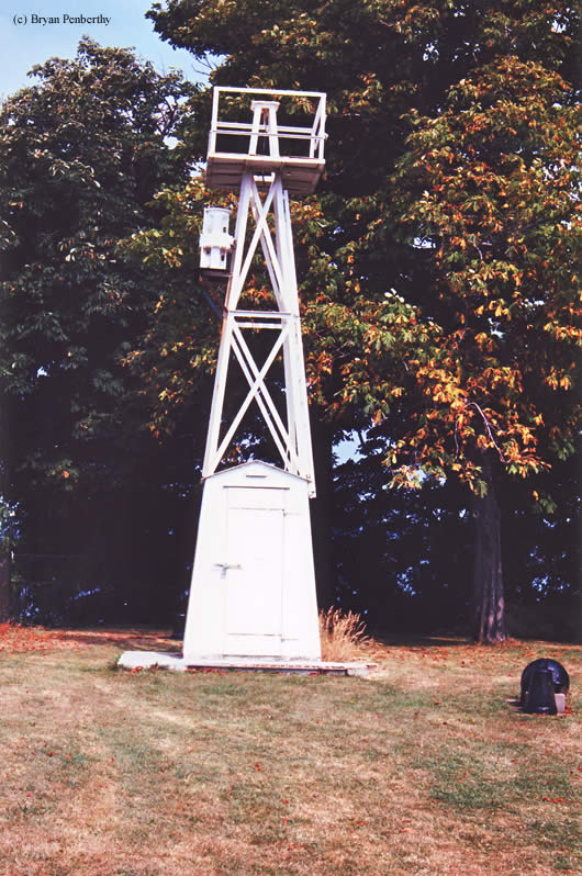
The Grand Island Front Range Light was a white pyramidal steel skeleton tower standing 29 feet above the water. From it, a flashing white light of 4,700 candlepower was exhibited. Its characteristic was one flash every second.
The Grand Island Rear Range Light was erected 515 yards 313½° from the front range light. This tower, also a white square pyramidal steel skeleton tower, stood 53 feet above the water and displayed an occulting white light of 4,700 candlepower every two seconds.
By 1924, the candlepower of the two range lights was listed as 12,000 in each tower. As the history of the lights is spotty, it is unclear when the Grand Island Range Lights were discontinued and removed.
After being discontinued, the Grand Island Front Range Lighthouse ended up on display at the Dunkirk Lighthouse and Veterans Museum. The disposition of the Grand Island Rear Range Light is unknown. It was most likely transferred to another location or may have been scrapped.
The Niagara River Rear Range Lighthouse Confusion
Standing on the grounds of the Buffalo Launch Club is the former Niagara River Rear Range Lighthouse. As this is close to where the original skeletal towers once stood, and is located on Grand Island, it is often misreported as the Grand Island Rear Range Light.
This, however, is not true. After the decommissioning of the Niagara River Range Lights in 1929, it was dismantled and barged to Grand Island by Charles and Frank Fix. It was later sold to Mike Steffen, who used it as a trophy room next to his house. From there, the property was annexed to the Buffalo Launch Club.
If you are interested, you can read more about the history of the Niagara River Rear Range Lighthouse.
Reference:
- Annual Report of the Light House Board, U.S. Lighthouse Service, Various years.
- Various Government Documents, Federal & State Governments, Various dates.
- www.isledegrande.com website.
Directions: The light sits on the grounds of the Dunkirk Lighthouse. From I-90, exit at exit 59 (Dunkirk) and take Route 60 west towards the lake. At Route 60 and Route 5 intersection, make a left onto Route 5. Follow Route 5 for a little more than one mile west. You will now see signs leading you to the lighthouse. You will make a right onto Point Drive North, and follow that into Point Gratiot Park.
For more information, please visit the official website: http://www.dunkirklighthouse.com.
Access: The lighthouse is owned by the Dunkirk Lighthouse and Veterans Museum. Grounds open in season.
View more Grand Island Front Range Lighthouse picturesTower Height: 27.00'
Focal Plane: 29'
Active Aid to Navigation: Deactivated (Unknown)
*Latitude: 42.49400 N
*Longitude: -79.35400 W
See this lighthouse on Google Maps.