Big Sable Point Lighthouse
Ludington, Michigan - 1867 (1867**)

History of the Big Sable Point Lighthouse
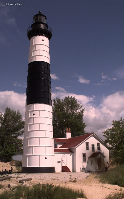
Dennis Kent sent in this wonderful picture shown here and had this to say about the light:
At the Ludington State Park, just north of Ludington Michigan is the Big Sable Lighthouse. Access is by way of a mile and a half walk around tufts of coastal sand dunes covered with dune grass. The sand and green grass ends at the blue waters of Lake Michigan and amid the puffs of white clouds is the black and white tower of this distinctive light.
Ships hug the coast at this point as it veers inward slightly toward Point Betsie. The 112 foot tall marker warns them not to approach too close. Area lumber mills created the commerce and as more ships were lost to the seas this light was built in 1867. It is still operational but not with the original third order Fresnel Lens.
As part of the State Park the lighthouse is open to visitors from May 1 to October 28. Pay just $2 and you can climb the 130 steps to a wonderful view of the shore and surrounding dunes. It was hard to imaging hauling oil and later kerosene up all those steps to fuel that beacon through storms and darkness. I had a hard time just with cameras. Children age 6-12 are just $1. We took a lunch and enjoyed it on a bench under a tree and watched freighter traffic off shore. If you need water or other beverages for your return walk there is a gift shop in the lighthouse.
Directions: From West loomis Ave. in Ludington, head north on North Lakeshore Drive or SR-116 and follow that into Ludington State Park. Pay your entrance fee to the park and get a park map. You have to park your car in a lot and follow the lighthouse trail up to the lighthouse. Just to warn you, it is a 1.5 mile walk each way.
View more Big Sable Point Lighthouse picturesTower Height: 112.00'
Focal Plane: 106'
Active Aid to Navigation: Yes
*Latitude: 44.05700 N
*Longitude: -86.51400 W
See this lighthouse on Google Maps.