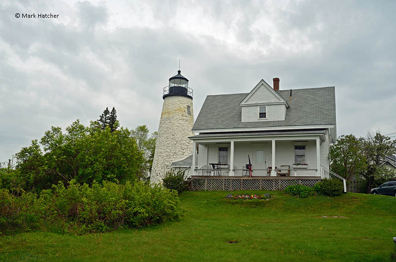
Dice Head Lighthouse
Castine, Maine - 1829 (1829**)

History of the Dice Head Lighthouse
Posted/Updated by Bryan Penberthy on 2018-05-19.
By the early 1800s, Castine was a busy shipbuilding town and a vital entrepot with a bustling harbor. In 1829, U.S. Government established the Dice Head Lighthouse to mark the port.
The state of Maine has long been contested between the French and British. One of the first explorers to land in the region was Samuel Champlain, a Frenchman, that led an expedition that landed on Mount Desert Island on September 5, 1604.
By 1605 most of the land area of northeastern North America, including parts of present-day Quebec and the Maritime provinces, were claimed in the name of the King of France. The French established Acadia, a colony of New France.
After creating a permanent establishment at Port Royal, Claude de Saint-Etienne de la Tour established a small trading post at the mouth of the Penobscot River in 1613. The settlement would be named Castine after French officer Jean-Vincent d'Abbadie, Baron de Saint-Castin, who held a French land grant in the area.
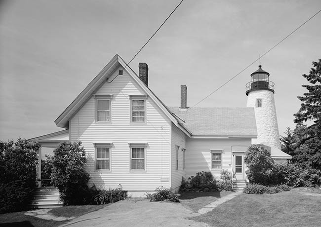 Dice Head Lighthouse (Courtesy Library of Congress)
An English raid on Mount Desert Island by Captain Samuel Argall in 1613 was the start of a long-running dispute over the border between French Acadia and English colonies to the south. Immediately after the raid, de la Tour re-established his trading post, and in 1625, erected Fort Pentagoet.
Castine and Fort Pentagoet would change hands numerous times between the British and the French over the next century. The region would stay contested until 1759 when the English had driven the French from Quebec, opening up the Maine coast to English Settlement.
The English annexed the region as part of the Commonwealth of Massachusetts. An act on February 10, 1796, split the towns of Castine and Penobscot. Before the split, Penobscot had been the county seat of Hancock County. As the county buildings were in Castine, Castine then became the county seat post-split, which it retained until 1838, when it was moved to the City of Ellsworth.
After the War of 1812, Castine returned to American control for good. In 1820, Maine seceded from the Commonwealth of Massachusetts, and on March 15, it was admitted to the Union as the 23rd state. It was around this same time that Castine had become an entrepot or a transshipment port where goods could be imported, stored, traded, or exported again.
Many mariners frequented the entrepot at Castine, which increased the number of vessels calling at the harbor. Fishermen on their way to the Grand Banks and long-distance traders between Europe and the Americas used entrepots as a way to sell their goods.
Due to abundant natural resources, Castine had quickly established itself as a center for shipbuilding and a major shipping port. It was said that in early springtime, more than 500 vessels were visible in the harbor and at one point, the town had the second highest per capita wealth of any city or town in the United States.
The Penobscot River was a critical link to the lumber-rich region around Bangor. As shipbuilding and lumber traffic on the Penobscot River steadily increased, Congress appropriated $5,000 for a lighthouse on Dice's Head on May 23, 1828.
The site chosen, the southern tip of the Castine peninsula, was a plot of land formerly owned by the Dyce family. Contractors had soon erected a conical rubblestone tower measuring 42 feet from the base to the focal plane. At the top was an octagonal wrought-iron lantern outfitted with ten lamps and 14-inch reflectors.
The keeper and his family resided in a one-and-one-half-story rubblestone dwelling which was adjacent to the tower.
Jacob Sherburne, the station's first keeper, lit the lights for the first time on the night of November 5, 1828. The fixed white light showed from 129 feet above mean high water.
The Secretary of the Treasury ordered Lieutenant Thomas J. Manning to inspect the light stations of the first district. Manning noted in his report that he provided the "information as far as the limited time would allow."
As such, most of the information in his report provided very little detail, if any at all. Manning's summary for Dice's Head Light consisted of one sentence, "In very good order." In 1842, Congress ordered a more thorough examination of the stations, which painted a different picture.
Isaiah William Penn Lewis, or I. W. P. Lewis as he was commonly known, carried out the orders. Whether being an engineer by trade, or he simply had more time to assess the light station than Manning did, Lewis's report showed a station that was in bad shape.
He described the tower as follows:
Tower of rubble masonry, 40 feet high, laid up in lime mortar of bad quality; walls opened by frost, and pointing cracked out; interior coated with ice during winter; soap-stone roof on deck, disjointed, loose, and leaky; wood work (viz: staircase, window frames and sashes, and lintels) all rotten; stairs unsafe to use. Base of tower rests on the natural surface of a ledge, without regard to level.
Lewis described the dwelling as having three rooms on the first floor, and two chambers in the attic. It too was laid up in lime mortar of inferior quality, had cracks in the walls, a leaky roof, and leaky windows.
He then commented that its location was a limiting factor of its usefulness and recommended using fewer lamps:
Location. As a harbor light for the port of Castine, this is useful. As a bay light, it is of little utility, though standing at the head of Penobscot bay; yet the site is so far east of the central line of said bay, that the light is intercepted by projecting land, and can only be seen in a certain direction and limited distance. Were it placed at the west side of Dice's head, it would then have a clear range down the bay to its limit of visibility. In its present position, one lamp of a proper form is all the navigation requires, instead of ten lamps now used.
An 1850 inspection report indicated that little had changed. The words "very leaky" were used to describe the tower.
New lamps and reflectors were installed in 1856 and the following year; the Lighthouse Board had recommended rebuilding the lighthouse. However, rather than being rebuilt, repairs were carried out instead in 1858.
At that time, contractors covered the tower in a six-sided wooden sheath, and a fourth-order Fresnel lens replaced the lamps and reflectors. It is unclear whether the cracks in the tower were repaired or merely covered over by the wood siding. It is said that the wooden siding was removed in 1878.
Repairs were carried out throughout the years. The exterior of the keeper's dwelling was repainted in 1867, the floors and tower stairs were painted in 1868, other general repairs were made in the 1880s, and a brick cistern was built in 1887. Before that, keepers had to carry water a distance of around 1,000 feet. The cistern was used until 1906 when the station was connected to the city water supply.
In 1888, 340 feet of wire boundary fence was put up to enclose the station. At that time, contractors erected a barn and replastered the dwelling. Several repairs were carried out in 1890, and a fog bell was established. The Annual Report of the Lighthouse Board for the year 1890 provided the details:
37. Dice Head, entrance to Castine Harbor, Maine - Three sides of the tower were reshingled, its lead flashing was renewed, and a 1,000-pound bell was provided and hung, to be rung by hand in answer to signals.
In response to a signal from passing vessels, the keeper was to ring the bell manually. This system went into place on Christmas day, 1890. A new hand striker was supplied to the keeper in 1897.
In 1895, an oil house was built at the station to store the more volatile kerosene.
By the early 1930s, maritime traffic in the area had diminished, and by 1935, the U.S. Lighthouse Service had automated the Dice Head Lighthouse. The keeper at that time, Vurney L. King, and his wife continued to live at the station as caretakers.
The U.S. Lighthouse Service discontinued the station in 1937, instead choosing to locate the light on a steel skeleton tower located close to the shore. At that time, the keeper's dwelling and surrounding land were turned over to the Town of Castine. To offset some of the costs involved with the historic light station and deter would-be vandals, the Town of Castine rented the keeper's dwelling to live in caretakers.
The tower sustained a lightning strike in September 1952 which blew out windows and a door and caused considerable damage to an attached workroom. The U.S. Coast Guard turned the lighthouse tower over to the Town of Castine in 1956.
Over the years, the tower continued to deteriorate. Aside from losing chunks of mortar, an inspection revealed decomposition from the interior of the tower. Residents of Castine voted in 1997 to spend $98,000 to repair the tower.
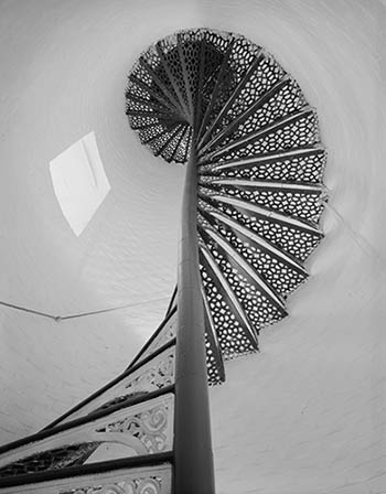 Steps inside tower (Courtesy L.O.C.)
The following spring, the town approved an additional $25,000 and received a gift of $52,000 from the Maine Historic Preservation Commission. Armed with $175,000, the Town of Castine hired Marty Nally, a contractor from the Campbell Construction Group to carry out a process called "slurry injection," which involved forcing liquefied cement through the holes in the tower.
Nancy Carr was one of the longest-serving caretakers at the Dice Head Lighthouse. Having arrived at the keeper's house in the early 1970s, as an artist, she used the sweeping views of Penobscot Bay as her inspiration for more than 40 years.
Carr was living at the dwelling in April 1999 when a fire started in the chimney and quickly spread to the roof. Luckily, she wasn't home at the time and was unhurt.
Dispatch received the fire call at 11:53 and firefighters arrived on scene within six minutes. As the firefighters were making progress, the hydrants went dry. Although they were able to locate another water source, it took more than six hours and 50 firefighters from three surrounding communities to extinguish it.
Although the tower was unharmed, the keeper's dwelling was damaged extensively. After some debate, the Town of Castine felt it was best to repair the damaged structure, instead of rebuilding it. That way, the dwelling would retain some historical integrity.
The town contracted with Philbrook and Spinney of Bangor, Maine to repair the dwelling. Crews carried out the necessary work and were completed by September 2000.
In September 2007, a microburst destroyed the skeletal steel tower in use since 1937. Rather than rebuilding the skeletal tower, the Coast Guard elected to install a new 300-millimeter optic in the 1829 tower, making it an active aid to navigation.
On January 1, 2008, the Coast Guard replaced the 300-millimeter optic with a 250-millimeter, which exhibited a white flash every 6 seconds. The light is still in use today.
Reference:
- Annual Report of the Light House Board, U.S. Lighthouse Service, Various years.
- Lighthouses of Maine: Penobscot Bay (Lighthouses Treasury), Jeremy D'Entremont, July 9, 2013.
- Maine Lighthouses: Documentation Of Their Past , J. Candace Clifford, Mary Louise Clifford, April 30, 2005.
- "Fire at Dice Head Destroys Keepers House," Staff, Lighthouse Digest, May 1999.
Directions: From the Town of Castine, follow Battle Ave south to the end. At the end, where Battle Ave meets Dyces Head Road, you will see the lighthouse.
Access: The Town of Castine owns the list station. The dwelling is rented to a live-in caretaker. Grounds open, dwelling/tower closed.
View more Dice Head Lighthouse picturesTower Height: 51.00'
Focal Plane: 130'
Active Aid to Navigation: Deactivated (1937)
*Latitude: 44.38274 N
*Longitude: -68.81908 W
See this lighthouse on Google Maps.