
Using GPS to find lighthouses
 Tweet
Tweet
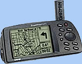
To start off, I will first list my GPS hardware information. I currently have a Garmin Streetpilot GPS receiver, USA and Canada Metroguide software, Garmin padded carrying case, and 16MB memory module. The receiver comes with a serial cable to load the software from your PC. and acigarette lighter power cable to preserve your batteries.
What is all this stuff you ask? Well, the receiver is the thing that is used to triangulate your position on the globe by taking measurements from up to 12 satellites. With the software, you can load in different maps to provide street level detail for areas that you will be traveling in. The 16MB memory module sits inside the receiver and provides a storage area for the maps from the software. And the carrying case is, well, a carrying case.
How does GPS work?
GPS stands for Global Positioning System.
This allows a person to find any particular point on the global by using a
set of coordinates (Latitude and Longitude). It uses a series of
satellites that are constantly circling the earth to triangulate your
position. Once your receiver has a lock on at least three satellites, your
position can be triangulated to within 3 meters (~ 10 feet) of your exact
location. Most receivers have what is called a 12 channel parallel
antenna. This allows the receiver to get a "lock" on up to 12
satellites.
Can a
global positioning system help you find lighthouses?
Heck yeah! All you need is aset of
coordinates (latitude / longitude) to calculate the exact positioning of
the lighthouse. How do you get the latitude and longitude of a lighthouse,
you ask? Well, many of the lighthouses that are still used as aids to
navigation by the US Coast Guard will have their cooridinates listed on
the US Coast Guard website.
This website is a little bit of a pain to navigate, but it works. The first thing you will want to do is pick the region that houses the lighthouse you are looking for. Next open the index for that region.Find for the lighthouse that you are looking for. I my case, I picked the Bass Harbor Lighthouse. Next to this lighthouse name is a number (2335). Now you go back to the main page that has the query methodson it.Pick Individual Aid Number, and in the boxput in your number, in my case 2335. Then click the search button.This brings up the individual aid number document, so click on the results. It then brings up all the characteristics of the aid.
One thing you will notice is that the coordinates are in degrees and minutes. My Garmin software and Microsoft Streets and Trips requires the coordinates to be in decimal format. This is pretty easy to change, so no need to worry. Bass Harbor came up with 44' 13"N by 68' 20"W. So what you will need to do is divide 13 by 60. This will give you the decimal equivalent of the minutes. So in my case, 13 / 60 = .21666. So my first coordinate will be 44.217. (I just rounded up). My next coordinate will be 20 / 60 = .33333 which is really 68.333.
So now when you go to your mapping software, in my case I use Microsoft Streets and Trips 2001, the first thing to do is turn on the location sensor. This is done under the TOOLS menu. Then, I usually first zoom in a little bit to the area where I think the lighthouse is. In this case, I zoomed in on the state of Maine. Then, by using the location sensor tool, I narrowed in on the coordinates. This took my in by Southwest Harbor. From here, I further zoomed in and narrowed my search down by using the .217 part of the coordinate. Then from here, you move east and west to get the .333 part narrowed down. Then, when I find the point, I usually mark it with a "pushpin" in the software. Inside the pushpin, I put the lighthouse name, and then the decimal coordinates so I can quickly see them.
What happens if the lighthouse that I am looking for
isn't listed in the Coast Guard's list?
This takes a little bit
more research. What I usually do is start with a bunch of lighthouse books
that I have. Many of the books provide you with directions. If so, then
pull up your mapping software, and follow their directions. This will put you in
the general area of the lighthouse on your software. Once in the area, I
will pick a spot that looks like where the lighthouse will be and mark
it. The spot that you mark will have coordinates in the location
sensor. I will use those as the "estimated"coordinates. If the book doesn't give you
directions, then you will need to check websites, etc. for directions. If
this doesn't work out, then you will need to guestimate as to the area,
then when you get in the area, ask someone for directions, or do a little
bit of searching.
How do you get the map loaded into the GPS
unit?
Good question. Unfortunately
Microsoft and the GPS don't play nice together. What I do is pretty much
just map each lighthouse again in Garmin's Metroguide software. Sure, this
is a little redundant, but I think Microsoft's software is a little nicer.
Garmin's software is more or less just line drawings because it gets
loaded into the GPS...and let's face it, two CDs of software aren't going
to fit into the GPS. Once you have each lighthouse mapped into Garmin's
software, send the maps and waypoints (lighthouses) to the unit. This can
be done a couple of ways. I have the serial cable connection hooked up to
my computer, but a much faster way is to use a USB programmer that accepts
Garmin's memory module.
Now what I do is go back to the Microsoft map software and print out the written directions. This works great because then your navigator can tell you which way to turnand how many miles you will be on a particular road, etc. If you put in all of your start and stop points into the Garmin software, you can use the GPS to "guide" you. Below is a screenshot of the GPS unit providing you direction.
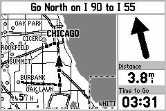
This isn't one of my actual screenshots, but rather one provided from Garmin. You notice at the top is the written directions, the arrow shows you which direction to head, and how many more miles to go. This also tells you how much longer until your arrival at waypoint, endpoint, or stopping point.
This is more or less just a very breif overview of how I use GPS to help me find lighthouses. I used this on my Michigan trip back in May of 2001. This helped out so much because if clarified situations where street signs were missing and when we were heading the wrong way. Some how we got turned around and were heading away from the lighthouse. I took a look at the GPS receiver and could see that. So we turned around and headed right up to the lighthouse. Another nice thing is that it will calculate your total mileage and total trip time. It can differentiate between stopped time and driving time and report both times back.
Additional
Resources
http://www.garmin.com
- manufacturer of many different GPS units.
[ Home ]