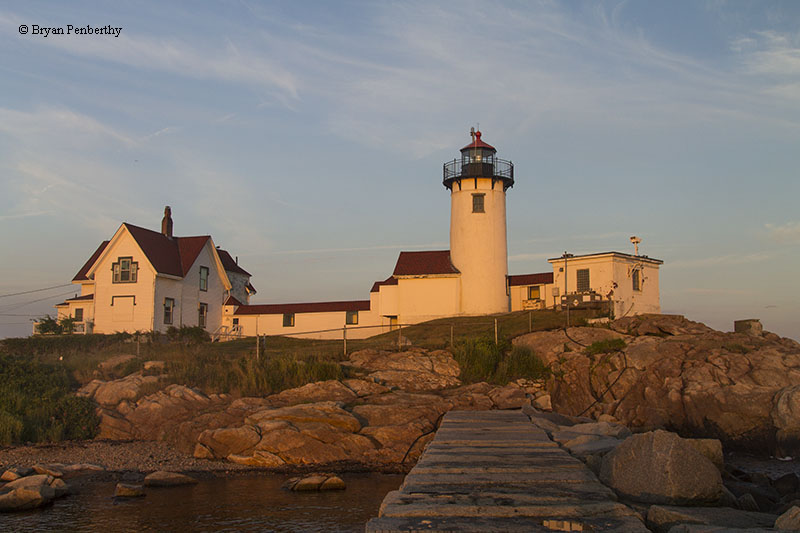
Eastern Point Lighthouse
Gloucester, Massachusetts - 1890 (1832**)

History of the Eastern Point Lighthouse
Posted/Updated by Bryan Penberthy on 2017-04-03.
By the 1700s, Gloucester was an important shipbuilding center and due to its proximity to many fishing banks in the Atlantic, including the Georges Bank and others off the coasts of Nova Scotia and Newfoundland, it quickly developed into a major fishing port. To mark the port of Gloucester, the Eastern Point Lighthouse was established in 1832.
One of the first English settlements in what would later become the Massachusetts Bay Colony took place in 1623 in Gloucester, predating the settlements at both Salem and Boston by several years. The town was soon abandoned in favor of Salem due to rocky soil, but was slowly resettled over time. It was formally incorporated in 1642.
By the early 1700s, Gloucester had become an important shipbuilding center. As time went on and it continued to grow, it morphed into an important fishing port due to its proximity to the many fishing banks in the North Atlantic Ocean.
By 1821, a lighthouse had been built on Ten Pound Island, but as the island sat inside the harbor, it did little for vessels in the Atlantic Ocean searching for the harbor. Vessels approaching from the north frequently mistook Bemo Ledge, known as "False Point," with Eastern Point, which often ended with dire consequences.
Mariners used a grove of oak trees upon Eastern Point as a landmark for numerous years, which was of little help at night. The Boston Marine Society, founded in 1754, took on the responsibility for safe pilotage in Boston Harbor and was instrumental in sponsoring measures to improve navigation. Some of their work directly led to the Cape Cod Lighthouse being built in 1797 and the Long Island Head Light built in 1819.
By 1829, the Boston Marine Society had started looking north towards Gloucester. That year, they wrote, "That it is the opinion of this Society, that the erection of a monument on Eastern Point Cape Ann, would be highly usefull [sic] to navigation in the Boston Bay-the old Land Marks of Trees being nearly decayed & gone-"
On March 2, 1829, Congress appropriated $2,000 "for the erection of a monument on the eastern point of the harbor of Gloucester." A tract of land was purchased from George Burnham for $100, and by the end of the year, an unlighted day beacon was established.
Although the residents of Gloucester had petitioned for a lighthouse, President Andrew Jackson opposed the request, most likely as retribution as Gloucester residents voted in favor of John Quincy Adams in the previous year's election.
As fishing traffic in the harbor continued to increase, it became apparent that a lighthouse was desperately needed. Congress appropriated $5,000 on March 3, 1831, which President Andrew Jackson approved.
As the previous stone day beacon had just been erected less than two years prior, it was decided to convert it to a lighthouse. Samuel Friend, the contractor hired to do the work, added a wrought-iron lantern with a copper dome to the structure.
Samuel Wonson, a local fisherman, was appointed as the station's first keeper. His yearly salary was $400. On the night of January 1, 1832, he climbed the 30-foot tower, and lighted the whale oil lamps. This displayed a fixed white light 58 feet above mean high water.
Wonson lived with his wife, Lydia, in a small brick dwelling nearby. The first floor contained two rooms and an attached kitchen, while the second floor contained two small chambers.
Lieutenant Thomas J. Manning was ordered to survey the lighthouses of the first district in 1838. He included an interesting sentence in his report stating, "I herein send you my report and give information as far as the limited time would allow." He included the following sentence regarding the Eastern Point Lighthouse:
Eastern point of Cape-Ann harbor light - This light has old-fashioned reflectors, although it is but five years old, and I think that it is in bad order.
Over the course of several years, Isaiah William Penn Lewis spent time at almost every lighthouse from Maine to Massachusetts collecting facts, information, and signed affidavits from the keepers regarding the conditions of the lights.
All this information was compiled into a report that was turned over to Congress in 1843. Lewis was critical of the tower, stating that the staircase and all woodwork were decayed and rotten, and the roof was loose and leaking. He recommended the tower be rebuilt.
The statement from Keeper Samuel Wonson, taken September 2, 1842, was more critical:
The light-house here was originally put up for a monument or beacon, and erected, I believe, in 1839. It is built of rough-split stone, laid dry, and pointed inside and out; the deck is soapstone; the leaks in every direction; the walls inside are covered with ice in winter, and green mould [sic] in summer; the window casings are loose in the walls, and rotten besides; the and door frames and sills are also rotten; the posts of the lantern only run down one foot in the walls, and in gales of wind it is wrenched and shaken so as to break the glass; the scuttle frame is entirely rotten; the rain blows in under the deck of the lantern, and runs through the walls. There are ten lamps here. The reflectors are worn out, and were second-hand when brought here.
A branch line of the Eastern Railroad was run to Gloucester in 1847, which led to an influx of immigrants. As more people made their way to the city, the fishing business experienced incredible growth, which further exacerbated the ineffectiveness of the Eastern Point Light.
 1848 Eastern Point Lighthouse (Courtesy Coast Guard)
In 1848, Congress spent $2,250 on a new 34-foot brick lighthouse, which contractor Winslow Lewis built on the original foundation. Inside the lantern was 11 whale oil lamps and 15-inch reflectors that were placed into service on November 3, 1848.
After the Lighthouse Board was established in 1852, most lighthouses in the United States were upgraded to the more efficient Fresnel lens. In 1857, the Eastern Point Lighthouse received a new lantern and a fourth-order Fresnel lens, which increased its visibility from 11 to 13 nautical miles.
The station received a fog bell that same year as well as an assistant keeper to help maintain it.
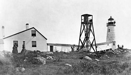
The fog bell was improved in 1868 when a new bell weighing 1,120-pounds was provided. A set of Stevens Striking machines and weights were also provided. The following year, on September 8, 1869, a gale destroyed the fog bell tower and severely damaged the striking machinery. To re-establish the bell as quickly as possible, it was hung on a temporary frame where it would be struck by hand, when needed. A new fog bell tower was erected in July 1877.
On April 1, 1878, the Eastern Point Lighthouse was changed over from fixed white to a fixed red light. French-made red plate glass panes were placed in the lantern earning the light the nickname "ruby light." On October 1, 1882, the light's characteristic was changed again from fixed to flashing red. A clockwork mechanism, periodically would by the keepers, rotated the light.
The new two-story duplex keeper's dwelling was built in 1879.
On April 28, 1890, a temporary light was displayed about 15 feet south of the lighthouse. This allowed the 1848 lighthouse to be demolished and a new lighthouse to be built. The Annual Report of the Lighthouse Board for 1890 had the following entry:
72. Eastern Point, entrance to Gloucester Harbor, Massachusetts - The old brick tower, built in 1831, was demolished, and a new brick tower 29 feet high, with a brick service-room was built upon the same foundation and surmounted by a modern fourth-order lantern with a 16 foot iron deck. The light-house land was inclosed [sic] with a fence of wire and turned cedar posts; the covered way was torn down and replaced by a plank walk, and several dilapidated fences and out-buildings were removed. A new bell-tower was erected on a more advantageous site; the fog-bell and striking machinery were removed to it, and the old tower was torn down. Minor repairs were made.
Although this entry states that the old brick tower was built in 1831, the tower that was replaced was built in 1848, but was built upon the original foundation of the 1831 tower.
The fog signal was of the utmost importance and was upgraded several times over the years. In 1886, a new and more powerful striking machine was installed and the characteristic was changed on May 1 to two blows in quick succession, at intervals of twenty seconds.
By 1896, preparations were being made to upgrade the fog signal again. By late that year, a new 4,000-pound bell, operated by a Shipman oil engine was established. It was placed into service on December 3, 1896. It appears that the fog bell was quite effective as, in 1898, a "reflector was put up, to diminish the intensity of the sound of the fog bell on the land side, and to increase it on the water side."
In 1901, the engine house was enlarged, allowing the 1-horsepower engine to be replaced with a 2-horsepower engine.
In 1923, the fog bell was changed over from a mechanical striking mechanism to an electrically operated bell. It operated that way until 1969, when the bell was removed in favor of a diaphragm foghorn. Today, the bell is on display on the station grounds.
As growing hostilities led to the United States to declare war on Spain in April 1898, many lighthouses were connected by telephone under the appropriation of national defense. A telephone line to connect the Eastern Point Lighthouse with East Gloucester, Massachusetts was established and paid for out of the national defense budget. The following year, the telephone line was sold at auction.
As the keeper of the Eastern Point Lighthouse was also responsible for a gas buoy moored offshore, the Lighthouse Board recommended a boathouse be established at the station in 1899. On June 6, 1900, $500 was appropriated allowing the boathouse and slip to be built.
Dog Bar is a submerged reef running out from the end of Eastern Point directly into the mouth of the harbor, for nearly a mile. Over the years, many vessels were wrecked on it attempting to enter Gloucester Harbor.
To provide protection, between 1894 and 1905, the Army Corps of Engineers built a 2,250-foot breakwater to protect Gloucester Harbor from heavy seas and swells from the south, as well as mark the Dog Bar Reef.
At the end of the breakwater, a wooden tripod displaying a fixed white light was established on December 14, 1905. The keeper of the Eastern Point Lighthouse was also given the added responsibility of the new Gloucester Breakwater Light, which is more commonly known as the Dog Bar Breakwater Light today. The task was oftentimes dangerous during high seas and cold temperatures, which left the breakwater ice covered.
In 1908, a second keeper's dwelling was added to the station.
 Eastern Point Lighthouse (Courtesy Coast Guard)
Storms near the Eastern Point Lighthouse were quite spectacular. During the great blizzard of February 6-7, 1978, winds gusting to 80-mph sent waves crashing into the eastern side of the buildings damaging machinery and nearly destroying the garage.
During another storm in the 1980s, the seas were so high, Coast Guard keeper Michael Mone witnessed a vessel being driven over the 35-foot high breakwater. Neither of those compare to the "Perfect Storm" of 1991 that formed when a Nor'easter absorbed Hurricane Grace. It was during this storm that the Andrea Gail, a fishing vessel out of Gloucester Harbor went down in the North Atlantic Ocean, with a loss of all hands.
Monster waves were crashing against the east side of the house. Realizing that morning tide was going to be worse, Keeper Scott McClain and his wife began to make preparations. After moving items from the basement of the keeper's dwelling to higher ground and drilling holes in the walkway to the tower to keep it from collapsing from the weight of the water, Scott, his wife, and their two kids rode out the rest of the storm at the Eastern Point Yacht Club.
A diesel mechanic and photo enthusiast George B. Lenart captured a spectacular photo of the Eastern Point Lighthouse on October 31, 1991. He was called out for maintenance at the Eastern Point Yacht Club, and was forced to hunker down there overnight. The spectacular photo shows the Eastern Point Lighthouse being pummeled by huge waves.
The following morning revealed the devastation. A summer-house below the lighthouse was washed away, the seawall was over half-gone, the fence around the lighthouse property was gone, a concrete walkway was torn up and twisted, and the garage was severely damaged.
The Eastern Point Lighthouse was automated in 1985 and was added to the National Register of Historic Places in 1987. Plans were being made for the lighthouse to be leased to the Lighthouse Preservation Society in the 1990s, but the Coast Guard decided to keep the station for housing.
The Coast Guard made repairs to the station in 1993 and remodeled the interior of the dwelling in 1998. Today, the lighthouse is still an active aid to navigation as well as housing for the Coast Guard. Although the grounds are closed, the lighthouse is visible from the Bog Bar Breakwater.
Reference:
- Annual Report of the Light House Board, U.S. Lighthouse Service, Various years.
- The Lighthouses of Massachusetts, Jeremy D'Entremont, 2007.
- "Eastern Point Light," Jeremy D'Entremont, Lighthouse Digest, May 1999.
- "Remembrances of Eastern Point Lighthouse," Timothy Harrison, Lighthouse Digest, November / December 2012.
- Index to Public Works - Vol. VI, U.S. Government, 1906.
Directions: The lighthouse sits at the end of Eastern Point Road in Gloucester. Take East Main Street south. When East Main Street crosses Rocky Neck Ave. it will change names to Eastern Point Road. There is a parking lot next to the lighthouse, which is managed by the Massachusetts Audubon Society as part of the Eastern Point Wildlife Sanctuary.
There are "private road" signs posted, but visitors are permitted to drive to the lighthouse. If someone is at the gate, tell them you are going to the Audubon property at Eastern Point, and they should permit you access.
Access: The lighthouse is owned by the Coast Guard. Grounds / dwelling / tower closed.
View more Eastern Point Lighthouse picturesTower Height: 36.00'
Focal Plane: 57'
Active Aid to Navigation: Yes
*Latitude: 42.58000 N
*Longitude: -70.66400 W
See this lighthouse on Google Maps.