Navesink Lighthouse
Highlands, New Jersey - 1862 (1828**)

History of the Navesink Lighthouse
Posted/Updated by Bryan Penberthy on 2011-04-15.
The Highlands of New Jersey just south of Sandy Hook have always been an important day mark for mariners. Although some documentation suggests there may have been a navigational light located here as early as 1756, no one can say for sure whether it is true. Some of the documentation suggests that the area was a "lookout" to keep watch for approaching enemy fleets. If any were spotted, a light would be lit to ready a militia as far away as New York City.
The first recorded navigational beacons were built on the Highlands in 1828. Constructed of blue split stone, two octagonal towers were built 320 feet apart to mark the entrance to New York Bay. The keeper's house was constructed between the two towers, but was detached. To distinguish the towers, the Lighthouse Board assigned separate characteristics to each tower. The north tower would show a fixed white light while the south tower would have a rotating light to display a "flash." The towers would use a new illumination system designed and installed by David Melville which would use gas to produce the light.
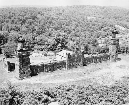 Navesink Lighthouse (Courtesy Coast Guard)
The Navesink Lighthouse would be the first lighthouse in the United States to use a Fresnel lens. In 1837, the publishers of the American Coast Pilot reported that many of the lighthouse in the U.S. were in poor condition and had inferior lighting systems, especially when compared to those of England and France. In 1838, Congress directed Stephen Pleasonton, Fifth Auditor of the U.S. Treasury to acquire two Fresnel lens. They sent Commodore Matthew C. Perry to France to acquire a first order Fresnel and a revolving second order Fresnel lens. In 1841, the first order lens was installed in the Navesink north tower, and the revolving second order lens was installed in the south tower. The Lighthouse Board called the Navesink Lighthouse "The best on the coast."
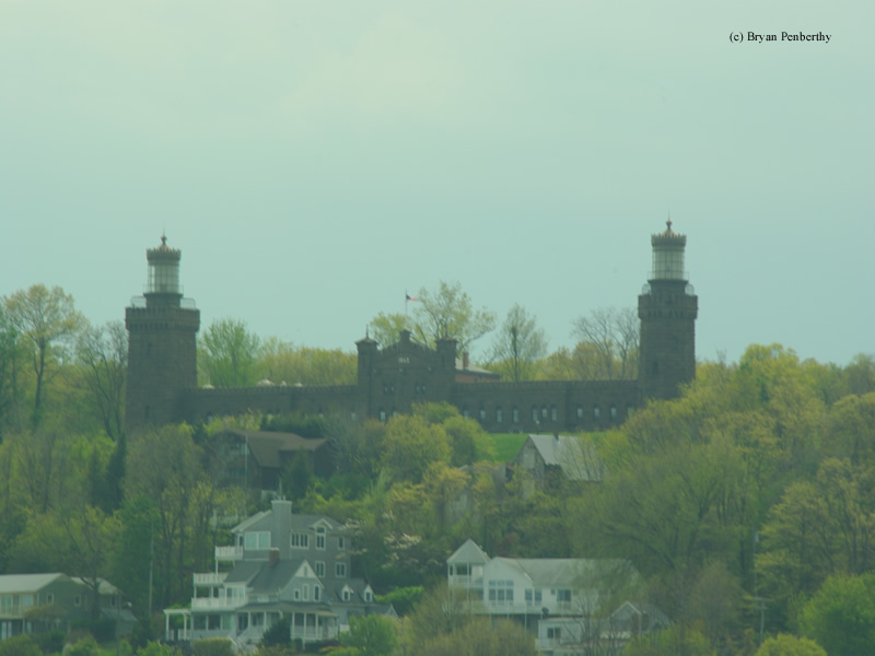
In 1857, The Lighthouse Board noticed that the towers were deteriorating and set about to replace them. Joseph Lederle was the architect employed to design the new towers and would give them a unique appearance. Both towers would be made of brownstone. The south tower would be square while the north tower would be octagonal with 228 feet separating the two. He would attach the two towers with the keeper's quarters in the center and storage rooms on either side. The Fresnel lenses would be moved over from the old towers and would be lit on May 1, 1862. The entire cost of the station was $74,000.
The Navesink Lighthouse would also be the site of another first for the Lighthouse Board. In 1883, the Lighthouse Board would experiment with using mineral oil for illumination. It would be the first lighthouse in the U.S. to burn mineral oil to power a massive first order Fresnel lens.
By 1898, the lighthouse would be tapped again for another experiment. This time, the Lighthouse Board would install a second order bivalve Fresnel lens in the south tower, and power it with electricity. A temporary generator building was built behind the south tower since no electrical service was available at the site. The electric-arc lamp in the south tower produced 25,000,000 candlepower and its light was visible at a range of 22 nautical miles. Shortly after this, the north tower was extinguished.
Less than a year later, on September 21, 1899, Guglielmo Marconi would demonstrate his new invention, wireless communication. The Lighthouse Board approved an antenna at the Navesink Lighthouse to receive broadcasts of the America's Cup Race which was being held off the tip of Sandy Hook, New Jersey. Marconi was aboard The Ponce with a transmitter using Morse code to send updates of the race. The display impressed members of the Navy and the Lighthouse Board so much so that Congress had appropriated funds to purchase equipment for several lightships and remote lightstations.
In 1910, a new permanent power house was created to replace the temporary generator building. However, by 1917, the generator that had powered the south tower's electric-arc lamp was nearing the end of its useful life. Given the cost to repair it, the Lighthouse Board opted to replace the electric-arc lamp with incandescent oil vapor lamps. This reduced the power of the lens to 710,000 candlepower.
Electricity would once again power the massive bivalve lens in 1931. This time, commercial electrical power was available to the lighthouse, so no generators would be necessary. Three 500-watt bulbs would provide the light raising the output of the lens to 9,000,000 candlepower. This was enough for Navesink Lighthouse to once again become the most powerful lighthouse in the United States.
Just before the start of World War II in 1939, the Army Signal Corps arrived at the lighthouse to conduct some long-range radar tests. Equipment being developed at Fort Monmouth in New Jersey was set up near the north tower, the tests were conducted, and the equipment was removed all while remaining top-secret.
With the rise in use of radar and radio-beacons to warn shipping traffic, the lighthouse became obsolete. It was discontinued in 1949. In 1951, the Fresnel lens in the south tower was removed, and put on display in the Boston Museum of Science. The Twin Lights Historical Society was formed in 1956 by a group of local citizens that were concerned of the welfare of the site. The group has continued to work with the New Jersey Division of Parks and Forestry since they took over ownership in 1962. In 1979, the group was successful in returning the Fresnel lens to the historic site, which is now on display in the generator building. The site is currently open to visitors, and the north tower is open for climbing.
Reference:
- Navesink Twin Lights: The First U. S. Lighthouse to Use a Fresnel Lens, Allen Weintraub, 2003.
- America's Lighthouses - An Illustrated History, Francis Ross Holland, Jr., 1972.
- Various Government Documents, Federal & State Governments, Various dates.
- Lighthouses of the Pacific Coast: Your Guide to the Lighthouses of California, Oregon, and Washington, Randy Leffingwell, 2000.
- "Twin Lights of Navesink Light Station Named National Historic Landmark," New Jersey Department of Environmental Protection, New Jersey Department of Environmental Protection, October 28, 2006.
- National Park Service website.
Directions: From Route 36 heading into Highlands, exit at Portland Road and make an immediate right onto Highland, Ave. Once on Highland Ave, you will make a left onto Lighthouse Road. Follow this a short distance to the Twin Lights State Historic Site.
Access: Tower and grounds open.
View more Navesink Lighthouse picturesTower Height: 73.00'
Focal Plane: 246'
Active Aid to Navigation: Deactivated (South: Active - North: 1949)
*Latitude: 40.39600 N
*Longitude: -73.98500 W
See this lighthouse on Google Maps.