Cape Romain Lighthouse
McClellanville, South Carolina - 1857 (1827**)

History of the Cape Romain Lighthouse
Posted/Updated by Bryan Penberthy on 2014-08-04.
Prior to the construction of any lighthouse on Cape Romain, there was a windmill which was often mistaken for the Charleston lighthouse, leading many vessels to their destruction. One such vessel that had been deceived was the Spanish schooner Diamonte in 1816, en route from Cuba to Africa, which resulted in the loss of twenty-one men of the fifty-one-man crew.
Due to the frequent groundings, the government of South Carolina stepped in to address the safety issues the windmill posed in November of 1821. The commissioners the South Carolina, proposed a resolution that permitted the state to place a daymark on the windmill. The resolution included the following language:
They are hereby authorized on behalf of the State to affix a cross or some other such mark to the said building in order to prevent in future as far as possible the serious calamities which have happened to mariners and others from the contiguity and the resemblance of the said wind mill and the Charleston Light House.
On March 23, 1823, Congress appropriated $10,000 for the building of a lighthouse on Racoon Key. The original plan was to purchase the windmill and convert it to a lighthouse, however, further inspection of the site revealed that it overflowed at high tide and would be subject to erosion.
The NE corner of Racoon Key, which was a more suitable location, was chosen for the beacon. Even so, a title dispute caused a prolonged time lag in construction which allowed the 1823 appropriation to run out. A new appropriation on May 18, 1826 provided $17,000 for a "light house or light vessel near Cape Romain."
By March of 1827, construction of the new lighthouse was underway by Winslow Lewis. When completed, a timber piling foundation supported a round, sixty-five foot tall brick tower. Within the lantern was Lewis's patented lamps and reflectors. Also constructed at that time was a keeper's dwelling, bringing the total cost of the station to $8,425. The light was exhibited for the first time on the night of June 1, 1827.
With a focal plane of 87.5 feet above sea level, the light was supposed to be visible for 18 miles to warn mariners of the dangerous shoals that extended off the coast of Cape Romain. However, mariners frequently complained that the light wasn't bright enough to be effective.
To remedy this, the lighting apparatus was upgraded to a system of 11 lamps and reflectors. The upgrade did little to help as the tower was too short. A report by Lt. David D. Porter, U.S. Navy, in June of 1851, talked favorably of the many lighthouses of South Carolina.
In his report, he listed the Cape Romain Lighthouse as a "very good one," but noted that its light grows dim towards morning. Another report filed that same year recommended that the tower be upgraded to a first-order lighthouse and that its height be raised to 150 feet.
The United States Lighthouse Board, established in 1852, moved the system of lighthouses, fog bells, and buoys from the oversight of the U.S. Treasury department and put them under the auspices of a group which consisted of distinguished military officers and civilian scientists who understood navigation.
The Lighthouse Board sought to upgrade many of the inferior lighthouses and requested $20,000 for the Cape Romain lighthouse. Congress obliged and the appropriation was made on March 3, 1853. After further inspection, it was found that the lighthouse could not be upgraded to a first-order tower.
The Lighthouse Board went back to Congress, and requested an additional $30,000 to establish a new first-order lighthouse at Cape Romain. Congress appropriated the additional funds on August 3, 1854. The appropriation contained the following language:
For a light-house to mark the shoals off Cape Romain, in the place of the present light at that locality, and for buoys to mark the inner channel, called the "Slue" in addition to the appropriation of March 3, 1853, for changing the present Iight at Cape Romain.
With slaves being used for labor, construction of the new octagonal, pyramidal 150-foot tall brick tower was started in 1857. While work was underway, it was learned that the walls were out of plumb due to the concrete foundation settling. Although it was to be corrected, when completed the tower still had a slight lean.
Inside the lantern sat a first-order Fresnel lens that was placed into operation on January 1, 1858. With a focal plane of 161 feet, the light was visible from 19 miles at sea. Rather than display a fixed white light like the old tower, the new one exhibited a bright flash, once per minute.
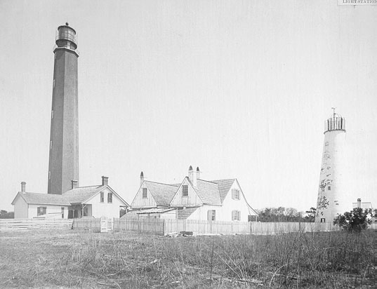
Typically, once a new tower was built and put into use, the old tower was torn down. This was not the case at Cape Romain. Not only was the old, 65-foot tall tower left standing, it was given a unique paint scheme of red with white horizontal bands to serve as a daymark. The new tower was left a natural brick color with the lantern painted black.
The lighthouse wouldn't be in use for long, as Governor Pickens of South Carolina seized all lighthouse property by January 8, 1861. Several miles to the south, in Charleston Harbor, during the early morning hours of April 12, 1861, the Civil War was started when shots were fired on Fort Sumter.
A report dated April 1, 1862 prepared by S.F. DuPont, Flag Officer, U.S. Navy, stated the following:
The tower at Cape Romain is standing, but the lantern and iron railing at top were all broken and the apparatus itself ruthlessly destroyed, the blockading officer who landed under it having picked up the prisms.
After the Civil War ended, Cape Romain was considered an important station, and was relit in 1866. By 1868, the tower had developed slight cracks on the north and south faces. The keepers monitored them over the years, but soon, the tower's concrete foundation began to settle.
By 1873, the lighthouse was nearly 24" out of plumb and had developed cracks on the westerly side as well. As the tower was so far out of plumb, the lens needed to be adjusted to bring it back to level. The Annual Report on the State of the Finances for that year had said that the tower may need to be replaced, and declared that "frequent observations will be made to determine this fact."
The following year, the tower had settled an additional 3-3/4" making the tower 27-1/4" out of plumb. The Lighthouse Board referred the matter to the engineering committee for analysis. Measurements taken frequently over 1875 showed no additional settling had taken place and the lens was still running with perfect accuracy.
To determine the character of the soil, the engineering committee took Artesian well borings 50 feet from the foundation. The soil was shown to consist of sand, mud, clay, and shells, with a solid bed of sand at 52 feet. Measurements taken in 1876, showed no additional settling.
An 1881 report deemed the keeper's quarters as inadequate for the families. That year, an additional keeper's cottage was built on the site. A few years later, in 1883, many changes were brought about. According to the Annual Report of the Lighthouse Board for that year, a well house was built, a new pump put in, and the tower was "colored."
Other changes continued in 1886 as the dwellings were repaired, the tower plastered, and the old tower was converted to an oil house. Also constructed at that time was a 12' by 30' boat house, connected to the land by a short plank walk. The Annual Report of the Lighthouse Board for that year had the following entry:
431. Cape Romain, 10 miles southwest of the entrance to Santee River, South Carolina - The roofs, windows, chimneys, and plastering of the keeper's and assistant keeper's dwellings were repaired, and a kitchen 14 by 20 feet in plan was built for one of the assistant keepers. Five sides of the main tower were cement-plastered and colored, and the old tower was fitted up for an oil-house by putting in a fire- proof door, laying a concrete floor, and fitting up shelves sufficient for 450 cans of oil. The fences were repaired and the station left in good order.
On the night of August 31, 1886, a powerful earthquake struck the Charleston area. It would later be known as The Charleston Earthquake of 1886 and, as the Richter scale wasn't developed until the 1930s, it was estimated to be between 6.6 and 7.3 on the Richter scale.
Although the head keeper was in bed with malarial fever, he reported the serene night leading up to the earthquake:
The day closed with only a breath of wind from the southwest, and a dark smoky-looking haze on the horizon line. When darkness set in the sky overhead was clear and the stars unusually bright and twinkling. He noticed that there was also an unusual fall of meteors during the night. About 7 p.m. the wind died away to a calm, remaining so all night, with a close atmosphere.
He went on to describe the scene at the station when the earthquake struck:
At 9:50 p.m. a low rumbling noise was heard in a west-southwest direction. The noise grew louder and louder, sounding something like a battery of artillery or a troop of cavalry crossing a long bridge. In less than a minute came the shocks, the first one lasting about two minutes, the next one about as long, with about two minutes interval. Shocks only a little less severe than the first two were felt at intervals during the night. The shocks did the tower no injury, but its vibration was great. Everything on the shelves was thrown down, the doors of the machinery-case were burst open, and a trap-door that leaned back at an angle of nearly 45 degrees was thrown down. The revolving machinery stopped only during the two heavy shocks, but went regularly afterwards. Nothing happened to the tower or the lantern to prevent a proper illumination of the station. All of the shocks seemed to be of a quick rotary motion. The clocks were all stopped in both tower and dwellings. Everything, such as vases and crockery, was thrown down and broken. It seemed a miracle that the tower and dwellings are now standing with little or no damage done to either, with the exception of a chimney thrown down and others cracked. The plastering in the dwellings is more or less cracked, and that is all the damage that has been done.
The old lighthouse tower, which was converted to an oil house, was whitewashed in 1888. The following year, most of the damage caused by the 1886 earthquake was repaired, which included plastering in the rooms and the leaks in the roofs of the dwellings. Extensive work to the fencing was carried out as well.
In 1891, additional settling of the foundation had occurred. Due to the settling, the lens was so far out of level, that adjustments were necessary. The following year, a new boat landing, measuring 8' by 60' was constructed, and connected to the shore by 95 feet of elevated plank walk. Additionally, 1,340 running feet of picket fence were put up.
A topographical survey of the station was taken in 1893. Additionally, the tower was checked to ensure no other settling had occurred. Several years had passed with only minimal repairs, until 1896, when extensive work on the boat house and landing was carried out. The Annual Report of the Lighthouse Board for 1896 had the following entry:
632. Cape Romain, South Carolina - The eight piles under the boat-house were remetaled and a bridge 20 feet long on metaled piles was built to connect it with the shore. A boat landing, nearer to the station than the boathouse, was also built and connected with the shore by a bridge 210 feet long. The structure was supported by 44 piles, 18 of which were sheathed with yellow metal. Various repairs were made.
Electricity was made available to the island in 1931 with the installation of a new generating plant constructed near the lighthouse. The lighting apparatus was upgraded at that time to a new revolving first-order bull's-eye lens. Inside the lens was a 500-watt bulb.
The Cape Romain National Wildlife Refuge was established in 1932 as a migratory bird refuge and covered 22 miles of uninhabited barrier islands and salt marsh along the southeast Atlantic coast. The refuge is made up of several islands, including Bulls Island, Cape Island, and Lighthouse Island, where the two Cape Romain Lighthouses stand.
The lighthouse was automated in 1937, and all human inhabitants left the island. Ten years later, the station was decommissioned, having been replaced with lighted buoys. With their decommission, they become part of the Cape Romain National Wildlife Refuge.
Both lighthouses are owned by the U.S. Fish and Wildlife Service. A local contractor named Tommy Graham took the first steps in 1992 to organize a group of volunteers and carry out several maintenance tasks, which included painting the 1857 tower, replacing missing window sashes, door frames, and glass panes in the lantern.
Trip reports to the island dated around 2002 report that the stairs inside the original 1827 tower were missing the lower section (around the first 10 to 20 feet), but the center post and upper section of the wooden staircase was still standing.
The 2002 trip report also stated that the 1857 tower is in good condition, however, as the windows had been missing for nearly 30 years, the interior has weathered quite badly. The salt air has begun to deteriorate the cast-iron stairs, leaving them in a weakened state.
More recently, a structural report by engineer John Moore carried out in 2011 found that the bolts holding the lantern to the tower were failing, and that a 110- to 120-mph wind would blow the lantern off the tower. The report also stated that the failing cast-iron treads cannot be repaired and will instead need to be replaced.
To stabilize the lantern, Moore designed a series of braces and straps that will hold the lantern at the four corners and connect to a cable that would pass through the hollow, cast-iron column at the center of the light and tie to the ground.
Suicide or Murder?
There is a folk story that has been around for a while of a lighthouse keeper of Cape Romain by the last name of Fischer, that murdered his wife for her gold and jewelry. The legend says that Keeper Fischer claimed that his wife committed suicide, and with no evidence to refute it, it was believed. Yet, on his deathbed, he conceded to the slaying.
Nevertheless, the true story really involves keeper Andrew Johnson.
Johnson, possibly spelled Johansen, who was of Norwegian descent, and his wife had lived on the island since 1867, however, on the night of April 8, 1873, his wife was found lying in the middle of a bed, soaked in blood, with her throat sliced from ear to ear.
Several days earlier, she had withdrawn jewelry and $1,400 cash from the South Carolina Loan and Trust Company, bequeathed from her previous late husband. Both went missing that night. The banker was told that her husband was going to use the money for a business venture.
What really happened that fatal night? Many theories abound.
Keeper Johnson claimed that she was depressed and wanted to return to Norway to be with family and friends, but the lightkeeper forbade her to go. With that, she committed suicide. Another theory was that Keeper Johnson hid the money and jewels that she was going to use to leave him, and that when she couldn't find them, she gave up hope and ended her life.
Another theory was that the assistant keeper, Julius L. Lee killed Johnson's wife, and took the jewels and money. Keeper Lee and his wife left the island shortly thereafter the incident. If Keeper Johnson did kill his wife, it apparently didn't bother him too much as he didn't leave the island for another two years, when he transferred to the Georgetown Lighthouse.
Was the keeper's cottage haunted? The legend said that drops of blood would mysteriously appear on the keeper's cottage floorboards, at the exact site of the murder, until the cottage was torn down.
Reference:
- Annual Report of the Light House Board, U.S. Lighthouse Service, Various years.
- Lighthouses of the Carolinas - A Short History and Guide, Terrance Zepke, 1998.
- Various Government Documents, Federal & State Governments, Various dates.
- A History of South Carolina Lighthouses, John Hairr, 2014.
- "A Visit to the Two Cape Romain Lights," Stephen A. Wilmoth, Lighthouse Digest, August 2002.
- "Saving lighthouse one man's passion," Robert Behre, The Post and Courier, December 28, 2011.
- "Murder or Suicide? The Cape Romain Lighthouse Mystery," Staff, Lighthouse Digest, March / April 2012.
Directions: The lighthouse sits 7 miles offshore from McClellanville. Travel to the island is only permitted in conjunction with the Sewee Visitor & Environmental Education Center guided tours. Other independent tours will take you past the island for photos.
Access: Access to the island is only permitted in conjunction with the Sewee Visitor & Environmental Education Center. Grounds and towers open during guided tours.
View more Cape Romain Lighthouse picturesTower Height: 150.00'
Focal Plane: 161'
Active Aid to Navigation: Deactivated (1947)
*Latitude: 33.01900 N
*Longitude: -79.37300 W
See this lighthouse on Google Maps.