Marcus Hook Rear Range Lighthouse
Bellafonte, Delaware - 1918 (1920**)

History of the Marcus Hook Rear Range Lighthouse
Posted/Updated by Bryan Penberthy on 2011-11-11.
This lighthouse, along with its accompanying front range light, was one of the last pairs of range lights built along the Delaware River to mark the new 35-foot channel that was dredged near Schooner Ledge. The upper lights were Chester Range Lights in Pennsylvania, where the lower range lights were the Marcus Hook Range Lights. The range lights are named after the town of Marcus Hook just over the border in Pennsylvania even though they sit within the state of Delaware. To get the lights up quickly, the Lighthouse Service set up temporary lights in 1915. The Reports of the Department of Commerce dated 1915 list the cost estimates of the front range light at $13,000 and the rear range at $24,000. The Lighthouse Inspector in Philadelphia was authorized on February 6, 1917 to solicit bids for the construction for both front range skeletal towers.
 Marcus Hook Rear Range Lighthouse (Courtesy USCG)
The Front Range light which sits between the towns of Claymont and Edgemoor, Delaware is nothing more than a skeletal tower set atop of concrete crib in the Delaware River. The light was automated from the beginning, using tanks of compressed gas to keep it illuminated for three to four months at a time. The temporary tower was replaced by a permanent one in 1918.
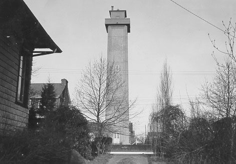
The Rear Range light sat one and a half miles behind the Front Range light on a hill overlooking the river. A temporary tower was erected while construction of the permanent tower was being planned, with the temporary tower being nothing more than a locomotive headlight mounted to the top of a tall pole. During the planning phase of the project, the government was having an issue getting clear title to the plot of land. Eventually condemnation proceedings brought the issue to resolution, and the land owner was awarded $2,050.
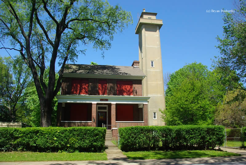
The lighthouse was not constructed as most other lighthouses at the time were. Instead, Rust Engineering Company of Pittsburgh, Pennsylvania, used reinforced concrete to construct the 105 foot tall tower. The tower is reinforced with buttressed corners, and has landings every twenty five feet connected by metal stairs. Just below the lantern room was a chart and radio room. From there, a metal ladder leads up to the lantern room and a four feet wide concrete balcony which surrounds the tower.
The original light source was a fourth-order Fresnel lens which showed a fixed white light of 24,000 candle-power. As importance grew, the light was later upgraded to 640,000 candle-power. The light is still active today, however, the fourth-order Fresnel lens as been removed in favor of a modern DCB-24 optic, and it now displays a fixed red light.
Also constructed at the time were the keeper's quarters and a garage. The keeper's quarters was a two and one-half story dwelling constructed of brick. The garage was a one car garage, with an attached workshop. Both of these were in use until 2004 when the Coast Guard left the property. In March of 2005, the lighthouse was listed under the National Historic Lighthouse Preservation Act, which would allow transfer of ownership to another government entity or a not for profit group, however none was recommended. In March of 2008, the Coast Guard awarded a grant of $37,500 to refurbish the front porch of the keeper's quarters. From the information I found, it appears that the keeper's quarters and garage were recently sold (summer of 2011) through the General Services Administration surplus property auction.
Reference:
- Annual Report of the Light House Board, U.S. Lighthouse Service, Various years.
- Guiding Lights of the Delaware River & Bay, Jim Gowdy & Kim Ruth, 1999.
Directions: The lighthouse sits at 313 Lighthouse Road. Lighthouse Road is just off Lore Ave.
Access: The lighthouse is owned by the U.S. Coast Guard. Tower and grounds are closed.
View more Marcus Hook Rear Range Lighthouse picturesTower Height: 105.00'
Focal Plane: 278'
Active Aid to Navigation: Yes
*Latitude: 39.76225 N
*Longitude: -75.50316 W
See this lighthouse on Google Maps.