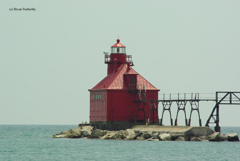
Ship Canal North Pierhead Lighthouse
Sturgeon Bay, Wisconsin - 1903 (1882**)

History of the Ship Canal North Pierhead Lighthouse
Posted/Updated by Bryan Penberthy on 2007-08-30.
Before the building of the Sturgeon Bay Ship Canal, the only way from Lake Michigan to Green Bay was via Porte Des Morts, which in French translates to "The Door of the Dead." The area encompasses several islands and shoals that extend from them. This leads to a narrow safe passage to travel between the islands and peninsula. In addition, winds are unpredictable and frequently become gale force without warning.
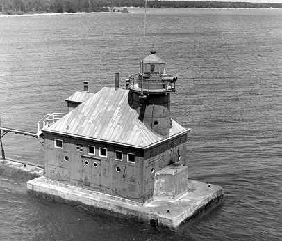 North Pierhead Lighthouse (Courtesy Coast Guard)
The idea behind the canal was from Joseph Harris Sr. He pushed the idea to a bunch of businesspersons, and once many learned that their investment could be recouped through tolls, they formed the Sturgeon Bay and Lake Michigan Canal Company. Most mariners were more than happy to pay the toll as it cut off almost 100 miles of the journey if they were to go around the tip of Door County.
When the canal first started, it was of little use to larger ships, as it was only 6' deep and 100' wide. The workers first started digging the canal in July of 1872 and by 1880, smaller boats began using it. By 1882, the canal was open for full navigation. At some point, the canal was widened to 125' and dredged to depths anywhere from 16.5' to 21.5'. The U.S. Government purchased the canal from the investors in 1893 and abolished the tolls.
Also in 1882, the first Ship Canal Pierhead light was established at the end of a jetty jutting into Lake Michigan. It was nothing more than a square wooden tower about 39' tall whose lower framework was exposed and housed a sixth order Fresnel lens. The elevated catwalk connected the tower to shore and allowed for safe passage.
August of 1884 brought the Lighthouse Board construction crews to the site to build a fog signal building. It housed a pair of 10" steam-powered whistles. Nevertheless, the steam-powered fog signals were very labor-intensive, and therefore, the Lighthouse Board added an assistant keeper to help. In 1886, the construction crews were back to build the second duplicate fog signal building and a wood framed dwelling to act as a keeper's residence.
Due to the poor condition of the original lighthouse, a new lighthouse and combined fog signal building was built in 1903 to replace the previous fog signals and residence. The present lighthouse is a two story wood framed building sheathed with steel plates to stand up against whatever Lake Michigan can throw at it. The tower pokes up through the eastern end of the roof to an overall height of 39', the same as the original lighthouse.
The sixth order Fresnel lens from the previous tower made its way to the new tower. It served for many years until its replacement with a more modern plastic optic. Like the first tower, this lighthouse also employs an elevated catwalk to allow safe access during heavy storms. Upgrades to the lighthouse took place in the 1920s. The fog signal would now be an air driven diaphone. To accommodate that, engine driven air compressors and tanks were added to the lighthouse. Eventually in the 1940s, the lighthouse was electrified. At this point, the air compressors and tanks were removed as the fog signal now used electricity to sound its warning. The lighthouse saw automation in 1972.
Reference:
- Great Lakes Lighthouses Encyclopedia, Larry & Patricia Wright, 2011.
- Wisconsin Lighthouses: A Photographic & Historical Guide, Ken & Barb Wardius, 2003.
- Lighthouses of Lake Michigan: Past and Present, Wayne S. Sapulski, 2001.
Directions: From Highway 42/57 in Sturgeon Bay, head east on Utah Street. At the intersection of Utah Street and Cover Road, head south on Cover Road for a block. You will then head east along Canal Road. Canal road will twist and turn, but follow it to the end. It will end at the Coast Guard Station. I am not too sure what the access is to the station. I visited during the Door County Lighthouse Walk and the grounds were open to walking.
Access: The lighthouse sits on the grounds of an active Coast Guard base. The grounds are typically open during the Door County Lighthouse Walk.
View more Ship Canal North Pierhead Lighthouse picturesTower Height: 39.00'
Focal Plane: 40'
Active Aid to Navigation: Yes
*Latitude: 44.79200 N
*Longitude: -87.30900 W
See this lighthouse on Google Maps.