Sturgeon Bay Ship Canal Lighthouse
Sturgeon Bay, Wisconsin - 1899 (1899**)

History of the Sturgeon Bay Ship Canal Lighthouse
Posted/Updated by Bryan Penberthy on 2007-08-30.
Before the building of the Sturgeon Bay Ship Canal, the only way from Lake Michigan to Green Bay was via Porte Des Morts, which in French translates to "The Door of the Dead." The area encompasses several islands and shoals that extend from them. This leads to a narrow safe passage to travel between the islands and peninsula. In addition, winds are unpredictable and frequently become gale force without warning.
The idea behind the canal was from Joseph Harris Sr. He pushed the idea to a bunch of businesspersons, and once many learned that their investment could be recouped through tolls, they formed the Sturgeon Bay and Lake Michigan Canal Company. Most mariners were more than happy to pay the toll as it cut off almost 100 miles of the journey if they were to go around the tip of Door County.
When the canal first started, it was of little use to larger ships, as it was only 6' deep and 100' wide. The workers first started digging the canal in July of 1872 and by 1880, smaller boats began using it. By 1882, the canal was open for full navigation. At some point, the canal was widened to 125' and dredged to depths anywhere from 16.5' to 21.5'. The U.S. Government purchased the canal from the investors in 1893 and abolished the tolls.
Since the Sturgeon Bay Ship Canal Pierhead light was completed in 1882, many mariners were calling for a more powerful shore based lighthouse. The Lighthouse Board recommended a new lighthouse for the Ship Canal in 1890, but it would take Congress three years to respond to this request, and another two years after that to authorize the $20,000 for building the light. Still, another three years would pass before construction crews would start.
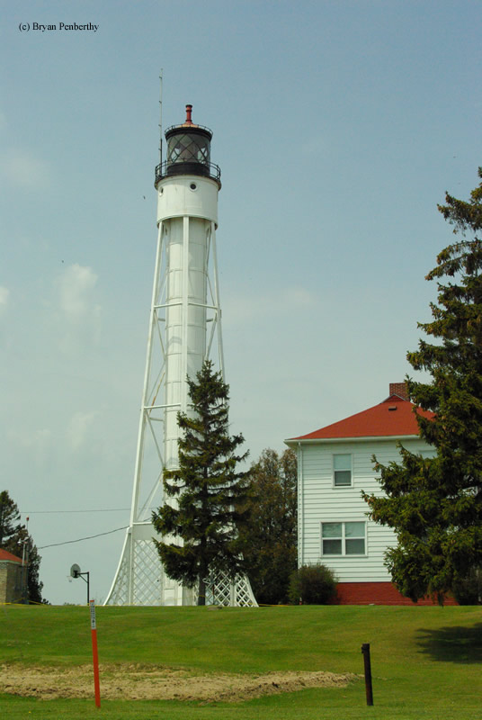
This tower would be different that most other towers on the Great Lakes. It would be an 8' diameter steel tube housing the staircase to the top. The tower was supported by eight steel buttresses which rose to 16'. This was the only bracing the tower had, and as the Lighthouse Board would later learn, was a problem. During frequent wind, keepers complained that the tower would vibrate, which reeked havoc on the clockwork mechanisms that rotated the lens.
Over the years, several corrections were proposed. The first one was guide wires from the lantern room to the sides. This did not correct the problem. In 1903, the Lighthouse Board added a steel support bracing around the entire tower and all the way to the lantern room. This new bracing would support the lantern room and lighting apparatus while the original steel tube would now only support the spiral staircase. This new design finally corrected the problem.
From the beginning, the tower housed a third order Fresnel lens, which is still in use today. The Fresnel lens beamed out alternating red and white flashes. The tower was originally painted brown with a black lantern room, but mariners had a hard time distinguishing it against the shore, so in 1900 it was changed to white. It was automated sometime in the 1940s.
Reference:
- Great Lakes Lighthouses Encyclopedia, Larry & Patricia Wright, 2011.
- Wisconsin Lighthouses: A Photographic & Historical Guide, Ken & Barb Wardius, 2003.
- Lighthouses of Lake Michigan: Past and Present, Wayne S. Sapulski, 2001.
Directions: From Highway 42/57 in Sturgeon Bay, head east on Utah Street. At the intersection of Utah Street and Cover Road, head south on Cover Road for a block. You will then head east along Canal Road. Canal road will twist and turn, but follow it to the end. It will end at the Coast Guard Station. I am not too sure what the access is to the station. I visited during the Door County Lighthouse Walk and the grounds were open to walking.
Access: The lighthouse sits on the grounds of an active Coast Guard base. The grounds are typically open during the Door County Lighthouse Walk. Tower closed.
View more Sturgeon Bay Ship Canal Lighthouse picturesTower Height: 98.00'
Focal Plane: 107'
Active Aid to Navigation: Yes
*Latitude: 44.79500 N
*Longitude: -87.31300 W
See this lighthouse on Google Maps.