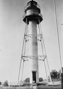
Plum Island Rear Range Lighthouse
Washington Island, Wisconsin - 1897 (1897**)

History of the Plum Island Rear Range Lighthouse
Posted/Updated by Bryan Penberthy on 2007-12-02.
The first lighthouse to mark "Death's Door", built in 1846, was on Plum Island. However, most mariners complained that the light on Plum Island was too far into the passage to be useful. The Lighthouse Board concurred and recommended Port Du Morts Island for a lighthouse in May of 1858. Port Du Morts Island, would later become known as Pilot Island. The original light on Plum Island, no longer needed after Pilot Island Lighthouse was in service, was abandoned and had all but fallen down by 1863.
 Plum Island Rear Lighthouse (CG)
Shipping traffic continued to grow on the Great Lakes, and so did traffic through "Death"s Door." The Lighthouse Board recommended another lighthouse be built on Plum Island since it lied directly in the middle of the shipping channel. The range lights would help guide ships between Plum Island and the tip of the Door County Peninsula. Although the request was submitted in 1890, no money was allocated until 1893, but it still was not appropriated, so therefore, no work could begin.
In 1895, the Life Saving Service requested funding for life saving station on Plum Island. Congress appropriated the funds for both projects, and by March of 1896, a crew of 30 men landed on the island to begin the work. To start, large areas had to be cleared for both projects. On the northeast side of the island, a 1.5 story "Duluth" style life saving station was built, and on the southwest side, the range lights. Along with both lights, the station would have a fog signal building, several boathouses and piers, as well as a tramway leading to the keeper's dwelling. All work on the station was complete by December of 1896. The rear tower had no lighting apparatus; installation would take place in March of 1897, just before the start of the navigational season.
The front range light was very similar in style to the Baileys Harbor Front Range, a two-story wooden tower with an octagonal top. The only difference was the cast iron lantern room on this range light. The lantern room housed a sixth order Fresnel lens that displayed a fixed red light. A modern steel skeletal tower would replace this one in 1964, which would display its light via a plastic optic.
The rear range light is 1650 feet away from the Front Range at a bearing of 330 degrees relative to the Front Range. The rear tower contains a center tube that houses the spiral staircase. Atop the tube, lies a cylindrical watch room topped off by an octagonal lantern room. Four iron legs, braced between each other, support the watch and lantern rooms. The lantern room, filled with a fourth order Fresnel lens, displayed a fixed red light. To make sure the light was only visible to ships either down range or already in the passage, it was restricted to an arc of 231 degrees.
The residence for the keepers was a two-story duplex made of Milwaukee cream brick located next to the rear range light. The station also had a fog signal building that was made of brick, which was located a quarter mile westward from the residence. Both the keeper's dwelling and the fog signal building are still located on-site, however, they are in terrible condition. From what I have read, the roof on the keeper's dwelling has already fallen through. The station was automated in 1969, and the fog signal was discontinued six years later.
As of October of 2007, the U.S. Fish and Wildlife Service are now in possession of the island. Some of the things the federal government had to do were to clean up the lead-based paint on the buildings and clean up grounds from a diesel fuel leak. This took place in 2004. Tim Sweet is leading a not-for-profit group called the Friends of Plum and Pilot Islands Inc. to try to save the lighthouse. The group will start raising funds for restoration; however, they do not know how much it will cost to restore the station.
Reference:
- Lighthouses of Lake Michigan: Past and Present, Wayne S. Sapulski, 2001.
- Lighthouses of the Great Lakes: Your Ultimate Guide to the Region's Historic Lighthouses, Todd R. Berger and Daniel E. Dempster, 2002.
- Great Lakes Lighthouses Encyclopedia, Larry & Patricia Wright, 2011.
Directions: The lighthouse sits off-shore on Plum Island which is owned by the U.S. Fish and Wildlife Service. Access is prohibited. The best viewing spot from land is at the Washington Island Ferry dock at the tip of the Door County Peninsula. Ideally, the best way to view the lighthouse is via a boat trip on the Washington Island Ferry which passes by Plum Island or one of the many other providers in the area.
Access: Grounds closed. Tower closed.
View more Plum Island Rear Range Lighthouse picturesTower Height: 65.00'
Focal Plane: 80'
Active Aid to Navigation: Yes
*Latitude: 45.30700 N
*Longitude: -86.95800 W
See this lighthouse on Google Maps.
