Baileys Harbor Lighthouse
Baileys Harbor, Wisconsin - 1853 (1853**)

History of the Baileys Harbor Lighthouse
Posted/Updated by Bryan Penberthy on 2007-12-02.
After an October gale popped up on the lake in 1848, Captain Justice Bailey needed shelter, and found it in a harbor that would later carry his name. While waiting out the gale, he set out to explore the island. What he found was an area rich is natural resources, such as limestone and many types of timber such as pine, beech, and maple. Upon learning this, Bailey informed Alanson Sweet, the owner of the shipping company he worked for, who in turn quickly set up shop to capitalize on the resources.
Alanson Sweet ended up convincing the state's legislature that the harbor would spur growth in the area. Upon this, the legislature responded by naming Baileys Harbor as the County Seat. After Sweet got the County Seat set, he and other shipping owners petitioned Congress for a lighthouse to mark the harbor. Congress agreed with the shipping owners about the need for a lighthouse and awarded Sweet the contract to build it. The year was 1852.
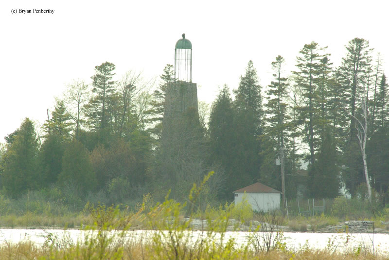
Sweet's construction crew surveyed the area and chose an island just offshore as the site for the tower. The fifty-two foot lighthouse was built out of rubble stone from Sweet's quarry and topped off with a rare bird-cage style lantern room. The lantern room received a sixth order Fresnel lens that emitted a fixed white light. By 1858, the Lighthouse Board removed the sixth order Fresnel lens and upgraded it to a fifth order.
The Lighthouse Board's 1866 annual report stated that the Baileys Harbor lighthouse was in very poor condition. Also noted in the report was that the lighthouse was not built in the best place to guide mariners into the harbor; therefore, a new tower should be built.
That tower would be Cana Island lighthouse, which is located about one mile north of the harbor. A pair of range lights, Baileys Harbor Front Range and Baileys Harbor Rear Range Lights would then guide mariners into the harbor. By the fall of 1869, both range lights and the Cana Island light were completed. However, the lights would not be lit until the start of the 1870 navigational season. Thus, Baileys Harbor light finished the 1869 season on December 1, 1869.
The island is now private property. From what I read, the cottage and tower are now used for summer occupancy only. However, it is noted that the bird-cage style lantern room is in very poor shape and is in danger of falling in. The cross supports of the lantern are rusted through, which is visible in the picture on this page. Because of this, this lighthouse is on Lighthouse Digest's Doomsday List.
Bird-cage style lantern rooms were very rare on lighthouses. So rare in fact that of the several hundred lighthouses located around the Great Lakes, there are only one three left in existence with this feature. They are Baileys Harbor, Selkirk Lighthouse in New York, and Waugoshance Lighthouse in Michigan. Of these three lighthouses, the only one not on the Doomsday List is Selkirk as it has undergone a restoration.
Reference:
- Wisconsin Lighthouses: A Photographic & Historical Guide, Ken & Barb Wardius, 2003.
- Lighthouses of Lake Michigan: Past and Present, Wayne S. Sapulski, 2001.
- Great Lakes Lighthouses Encyclopedia, Larry & Patricia Wright, 2011.
- Western Great Lakes Lighthouses, Bruce Roberts and Ray Jones, 1996.
- Annual Report of the Light House Board, U.S. Lighthouse Service, Various years.
Note: The lighthouse and island are private property, please respect this and do not trespass.
Directions: The lighthouse sits on an island off-shore. However, distant views are possible from the end of Ridges Road. From Highway 57 in Bailey's Harbor, head east on Ridges Road and follow that to the end. At the end, you will see an dirt parking area just off the road. From here, you can see the lighthouse on the island.
Access: The lighthouse and island are private property. Grounds and tower are closed.
View more Baileys Harbor Lighthouse picturesTower Height: 52.00'
Focal Plane: Unknown
Active Aid to Navigation: Deactivated (1870)
*Latitude: 45.05500 N
*Longitude: -87.09700 W
See this lighthouse on Google Maps.