Old Cut Lighthouse
Long Point, Ontario - 1879 (1879**)

History of the Old Cut Lighthouse
At one point, Long Point in Canada was called the Graveyard of the Great Lakes due to sandy shoals and fast approaching storms. Rather than make the 25 mile trek out past the point that would take them into the open lake, sometimes smaller vessels would actually portage across the isthmus. This was a luxury that many larger ships just didn't have.
In the late 1700s to early 1800s, the Canadian Government was getting ready to dredge a channel through the Long Point Peninsula when a storm whipped up off the lake and created one. It was close to 390' wide and had a minimum depth of 11 feet. Piers were created to help mark and keep the channel open. Given the uncertainty of how long the cahnnel would be usable, the Government marked it with a lightship due to its portability. The year was 1840.
Since the channel was never maintainted over the years, it did eventually fill in. By 1895, the lake side of the channel was completely filled in, and by 1906, the bay side was closed off. Luckily storms during the year 1865 had opened up a new channel in the peninsula. This channel would be known as "The Cut." It wasn't as wide as the other channel, but it was 20' deep. This time, the Government built a lighthouse to mark it.
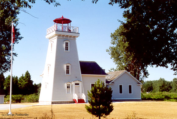
The lighthouse would be 60-65 tall, and the tower would be built into the northwestern corner of the keeper's house. At the time the tower was built, there was nothing near the tower. If the keeper wanted any human interaction, he would have to row to Port Rowan. This was remedied in 1908 when a telephone line was brought to the tower.
The lantern for the cut was a unique one. In fact, there were two lanterns in the tower. Red on top, and white on the bottom. Pirates used to copy this exact same sequence of lights on the shore during stormy weather falsely luring ships to their demise. They would then pillage the ship's cargo. Due to the remoteness of the area, by the time authorities would arrive, the pirates would be gone.
Like the earlier channel before, mother nature would soon reclaim the cut. The cut was being filled in with silt, and new shoals formed in the shipping lanes on the approach to the cut. This coupled with the reduced shipping traffic led to the decommissioning of the Cut Light in 1916. By 1918, the lantern was removed, and it was sold off.
The lighthouse changed hands numerous times since decommissioning. The first owner used it as a cottage. By the 1960s, and I believe the third owner would rent out the cottage for $1000 a month. The tower was sold again in 1968. Over the years, some things did change. Where there was once nothing, the area around the tower was now bustling community of summer cottages. Instead of the lighthouse directly on the water, the beach was now almost 1/4 of a mile away. Instead of the lantern room, one of the owners during that time put a new top on. Instead of looking like a lighthouse, it resembled the tower of a fort.
By 1999, it was on the market again. The broker interviewed many potential buyers and some crazy ideas as well. One included tearing the lighthouse down to make a parking lot! The broker eventually found the right people to buy it. Their idea was simply to restore it. The couple spent several years restoring it as best they could. They hired an architect to help them blend old with new in a seamless way. The fort-like tower was removed and a lantern room replica was reinstalled. Overall, from what I can see, they did a great job.
Note: The lighthouse is private property, please respect the owner's privacy and do not trespass.
Directions: From Simcoe, take County Route 24 south and west. At the intersection of Route 24 and Route 59, make a left onto Route 59 and follow that south almost 10 miles to the lighthouse. The lighthouse is along Route 59 just past the Long Point Provincial Park. Please note that the lighthouse is private property. Please do not trespass.
View more Old Cut Lighthouse picturesTower Height: 53.00'
Focal Plane: Unknown
Active Aid to Navigation: Deactivated (1916)
*Latitude: 42.58200 N
*Longitude: -80.39600 W
See this lighthouse on Google Maps.