East Charity Shoal Lighthouse
off Cape Vincent, New York - 1877 (1935**)


History of the East Charity Shoal Lighthouse
Posted/Updated by Bryan Penberthy on 2014-11-09.
In the heart of the shipping channel leading to the St. Lawrence River stands the East Charity Shoal. Water depths among the shoal range from one meter to more than ten meters. Although it was unlighted for many years, the Lighthouse Service eventually established the East Charity Shoal Lighthouse in 1935.
The origins of the shoal remain a mystery, although on numerous nautical charts an equi-dimensional circular depression nearly 1,000 meters in diameter coincides with Charity Shoal. Although it is a possibility that the crater was a sinkhole that formed in the limestone, it is more likely the result of a meteor impact as it has a rim encircling it and the Geologic Survey of Canada detected a negative magnetic anomaly over the impact zone which is characteristic of a meteor impact.
Although shipwrecks in Lake Ontario have occurred as early as the 1600s, one of the most widely known shipwrecks happened on December 5, 1897 when the steamer Rosedale was grounded on Charity Shoal.
The Rosedale, built in Sunderland, England in 1888 for the St. Lawrence and Chicago Shipping Company, was headed down Lake Ontario, from Fort William to Prescott with 65,000 bushels of wheat when it ran aground on the shoal.
Efforts made by tugs to free the stuck vessel failed. Although the vessel was written off by its insurance company, a salvage contract was made to the Donnelly Wrecking Company. They proceeded to pump out the vessel and patch it enough to bring it into dry dock at Kingston, Ontario, where it was eventually rebuilt and returned to service.
Not only are the shoals a danger to mariners, others feel there is something "otherworldly" going on in the area comparing it to the Bermuda Triangle. For several centuries, there are supposed to have been over 100 shipwrecks near the East Charity Shoal giving it the name "Graveyard of Lake Ontario."
There have been reports of the entire crew of vessels going missing as early as May 22, 1889 when the entire crew of the Bavaria disappeared in the midst of a storm on Lake Ontario.
The steam barge Calvin was towing the Valentia, the Norway and the Bavaria when the towing line broke separating the vessels. A minor collision of the Bavaria and the Norway ensued, neither of which sustained hull damage. After the collision, the Norway made sail for a nearby island where they anchored and waited out the storm.
The Bavaria broached and fell into the trough of the seas. The captain of the Calvin could see that the Bavaria was taking on water, he turned around and drew abreast of the Bavaria, where he expected to see Captain John Marshall or a member of the crew.
When no one showed to affix a new hawser, the Calvin blew its whistle to try and raise someone. The Calvin stood by until the Bavaria drifted too close to Galloo Island and grounded. After the storm subsided, the passing schooner Armenia sent a boat crew to investigate.
The crew of the Armenia found the Bavaria intact and in good condition, with only the lifeboat missing suggesting the crew abandoned ship. However, on board, they found the captain's important papers, a box of money from the deliveries made, and a bread baking in the oven.
Eventually, the lifeboat was found floating upside down a few hundred feet from the ship. From what transpired, it was concluded that the crew abandoned ship almost immediately after the line broke, and shortly after that, the lifeboat capsized and all drowned. But no bodies every turned up.
This led to many questions being asked such as why a seasoned ship captain would abandon a seaworthy ship and take his chances in an open boat during a gale? Why wouldn't the captain attempt to raise sail, and bring the vessel out of harm's way as the Norway did? The Bavaria had a cargo of lumber, so if it were to take on water, it would sit lower in the water, however, it would not sink.
The next event of a missing crew happened on June 29, 1900. Three schooners, the Picton, the Anne Minnes, and the Acacia, were traveling in a caravan from Rochester, NY to Kingston, Ontario. The Picton was leading when it appeared to be in distress. When the Anne Minnes was within a little over a mile from the Picton, it foundered.
When the Anne Minnes arrived on scene, they traveled through a large debris field, including spars, fenders, etc., but no crew. One of the crew members thought they saw a body of a boy in the water and threw a rope to him, but the boy made no attempt to reach it.
Some even speculate that the crew might have been washed off the ship before it went under. After hours a searching for survivors, the crews of both schooners reluctantly gave up the search and continued on to their destinations. Again, no bodies were ever found.
Nearly two months later, a child found a bottle that washed ashore with a note inside. The note read:
John Sidley, Captain of the schooner Picton, in great peril. Expect to sink at any minute. Goodbye to all friends. Finder please report to my wife.
Not only have disappearances been reported in the area, but in later years, reports of UFOs and "flying orbs of light" hovering over the surface of Lake Ontario have been reported. In the 1980s, the term "Marysburgh Vortex" was coined to refer to the area between Wolfe Island, Mexico Bay near Oswego, NY, and Pointe Petre in Price Edward County, Ontario where these mysterious events took place.
During August of 1900, John C. Churchill, Jr. of the United States engineer's office in Oswego, NY was given the orders to survey Charity Shoal. Chartering the steambarge J.G. Nichols, he set off on the morning of August 22, 1900 from Cape Vincent, and proceeded ten miles to the East Charity Shoal.
The result of Churchill's survey concluded that the East Charity Shoal was more than 3,000 feet long with an average water depth of sixteen feet. However, the survey revealed a larger shoal to the south, nearly a mile long, which was given the name South Charity Shoal.
As there was adequate deep water on either side of the shoals, they weren't removed. Instead, they were marked with a nun buoy on easterly edge of the East Charity Shoal and a notice to mariners was issued to "keep to the eastward of this buoy." Eventually, by 1910, the shoal was marked with a lighted buoy showing a white light for 10 seconds, then eclipsed for 10 seconds.
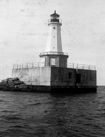 East Charity Shoal Lighthouse (C.G.)
However, this did little, and shipwrecks continued. It would take until 1934, but finally a notice went out in several papers looking for sealed bids to build a "timber crib-concrete superstructure on East Charity Shoal." Interested entities would have until June 5, 1934 to submit a bid.
Out of the bids, the Walls Company was selected and had constructed a 50-foot by 50-foot crib standing 18 feet above Lake Ontario. A temporary pole light was established on the south side of the crib on November 24, 1934. At this time, the buoys marking the shoal were discontinued.
The tower that would become the East Charity Shoal Lighthouse was originally installed at the end of a pier in Vermilion, Ohio in 1877. It served that harbor for many years until it developed a dangerous lean when the pier was damaged by ice in 1929. After being brought to the attention of the Lighthouse Service, it was taken down and transported to the Buffalo, New York Lighthouse Depot.
It sat at the Buffalo Lighthouse Depot for many years until a suitable location for reuse was found on the crib established at East Charity Shoal. During the summer of 1935, the iron lighthouse was erected on the crib and outfitted with a fourth-order Fresnel lens. Illuminated by acetylene, the lighthouse was never staffed by a keeper, it was immediately automated.
As it was no longer needed by the U.S. Coast Guard, on July 23, 2008, the General Services Administration advertised the East Charity Shoal Lighthouse as available under the National Historic Lighthouse Preservation Act of 2000. This act made the lighthouse available at no cost to an eligible entity defined as federal, state, or local agency for education, cultural, or historic preservation purposes.
As no eligible entity came forth, the lighthouse went to a public auction in May of 2009. On August 27, 2009, the lighthouse was sold to Cyrena Nolan of Dallas, Texas for $25,501.
Note: The lighthouse is private property, please respect the owner's privacy and do not trespass.
Reference:
- Annual Report of the Light House Board, U.S. Lighthouse Service, Various years.
- Various Government Documents, Federal & State Governments, Various dates.
- "Salvage work on the S.S. Rosedale," Marine Publishing Company, Marine Engineering, Volume II, 1898.
- "Legal Notices," Staff, Oswego Palladium-Times, May 14, 1934.
- "Marine News," Staff, Oswego Palladium-Times, November 28, 1934.
- Bulletin No. 21, Survey of Northern and Northwestern Lakes, U.S. Lakes Survey Office, 1912.
- "Strange Disappearance of The Bavaria's Crew," James Donahue, Great and Lost Ships of the World, .
Description: This lighthouse sits out in Lake Ontario well offshore. The best view of this lighthouse is from the water, however, distant views are possible from the grounds of the Tibbetts Point Lighthouse. While in Cape Vincent, follow Broadway Street west to the intersection with Route 6 (Pleasant Valley Road). At this point, Broadway Street will turn into Tibbetts Point Road. Follow this to the end, and you will be at the lighthouse.
Access: The lighthouse is private property. Tower closed.
View more East Charity Shoal Lighthouse picturesTower Height: 16.00'
Focal Plane: 52'
Active Aid to Navigation: Yes
*Latitude: 44.03300 N
*Longitude: -76.46600 W
See this lighthouse on Google Maps.